
Operation Empire: They Were Given Missions

Jesuit priests and the founding of modern “Science”…
It was written in the archives that Galileo traveled to Rome, in 1611, to present his findings, and was greeted with great acclaim.
He demonstrated his observations of Jupiter to Christopher Clavius, a Jesuit at the Collegio Romano and the most respected astronomer in Europe at the time, who confirmed Galileo’s observations and parts of his theses of planetary motion.
No coincidence that Christopher Clavius was the senior mathematician on the commission for the reform of the calendar that led, in 1582, to the institution of the controversial Gregorian calendar.
Beware of Deceptive Foundations:
- for Commerce & Bills of Exchange
- for Institutional Governance
- for the modern Calendar
- for Astronomy
- for cosmology
- for Science
…and countless other Catholic priests in positions of power and influence.
Are you able to study afresh with improved skills of discernment to critically, examine everything observed?
Are you able to question everything that you read and was taught?
Are you able to endure the criticism and disrespect for asking questions about the validity of dogma and authority?
Know this, Truth Seeker:
Seeking the Truth is akin to walking in a dangerous minefield!
Your questions and facts are unwelcomed by the established consensus.
Family and friends may be the first to toss a grenade at you, hopefully it will only be a verbal explosion…
– They Were Given A Mission –
Paid well to keep a secret…
– They Were Given A Mission –
Paid well to explain and promote this new curriculum…
– They Were Given A Mission –
Paid well to recruit and convert…

What is a Superior General?

Since Saint Ignatius was elected as Superior General of the Society of Jesus in 1540 and as he wrote the Constitutions of his Order, the Superior General has always been elected for life by a “General Congregation” of Jesuits, representatives of their provinces around the world.
The mission of the Superior General consists in guiding the Order, according to the Constitutions and Norms and the Guidelines of the General Congregations.
The two last Superior Generals, Frs. Pedro Arrupe (1965-1983) and Peter-Hans Kolvenbach (1983-2008) have asked and received permission from the pope to step down as Superior General. –The Jesuit Curia in ROME
Notice the exploits of these Jesuit priests:
- Christoph Clavius (1537-1612) Jesuit mathematician and astronomer manage the Herculean task, after several failed attempts, of commissioning calendar reform for the Papacy in Rome.
- 1540 Paulus III (Pope Paul III) recognized “Society of Jesus” forming about Ignatius de Loyola, and as “Jesuits” formulated their mission in the world at large (live freely as men rather than restricted in monastery ordered life), and specifically in three areas, teaching, service to the nobility, and missionary work in foreign lands.
- 1538 Jesuit Education is formed
Jesuit’s first seminary and education college was the Collegium Anglicus or College of English… - “In February 1551, prior to the recommencement of the second period of the Council of Trent (1551-52), Roman Pontiff Julius II (III) (1550-1555) ceded the Collegium Romanum (“Roman College”) to the control of the Company of Gesu (Jesuits) and Ignatius of Loyola as Superior General (1541-1556) granting its headquarters at the base of Capitoline Hill”
- José de Acosta (1540–1600), one of the first naturalists and anthropologists of the Americas.
- Matteo Ricci (1552–1610), Italian mathematician, translator, and noted for his importance to the Jesuit China missions.
- François d’Aguilon (1567-1617), Belgian mathematician and physicist who worked on optics.
- Giuseppe Biancani (1566-1624), Italian astronomer and selenographer who wrote Sphaera mundi, seu cosmographia demonstrativa, ac facili methodo tradita.
- Wenceslas Pantaleon Kirwitzer (1588-1626), Czech astronomer and missionary to China.
- Christoph Grienberger (1561-1636), Austrian astronomer and mathematician.
- “Thanks to Pope Gregory XIII, the Jesuits were the only religious Order with the power to conduct commerce and banking.”
- Claudio Acquaviva (1581 – 1615 ), reportedly, ordered Fr Vilela S.J. to purchase the port of Nagasaki from a local Japanese warlord. Acquaviva then appointed Alessandro Valignano S.J. to manage the new commercial mission.
- “In 1602, General Claudio Acquaviva assisted the Jesuit merchants to gain a 21 year charter of monopoly from the States-General of the Netherlands to form the Vereenigde Oostindische Compagnie or VOC in Dutch, literally “United East Indies Company ( Dutch East India Company).” See Jesuits one-evil.org
- Napoleon, France, Italy, and Switzerland
1796 The Jesuits through Switzerland formed the private banks Darier Hentsch & Cie and Lombard Odier Darier Hentsch as custodians for all gold, treasure and contracts seized during the campaign… - Angelo Secchi (1818-1878), Italian astronomer who discovered the existence of solar spicules and drew an early map of Mars.
- Pierre Teilhard de Chardin (1881–1955), French palaeontologist and philosopher involved in the discovery of the so-called Peking Man.
- Georges Lemaître, (1894-1966), Belgian cosmologist, Catholic priest, and father of the Big Bang theory.
- First Jesuit Pope
Jorge Mario Bergoglio became the first Jesuit Pope, taking the name Pope Francis in 2013.
…and countless other Catholic priests.

Pope Benedict XVI (R) greets British professor Stephen Hawking during a meeting of science academics at the Vatican October 31, 2008. REUTERS/Osservatore Romano (VATICAN)
Vatican Observatory
![]()
{Do you have any thoughts about the Vatican Advanced Technology Telescope on Mt. Graham with a infrared camera and spectroscope named LUCIFER?
It took some extra effort to create that acronym:
“L.U.C.I.F.E.R.
which stands for “Large Binocular Telescope Near-infrared Utility with Camera and Integral Field Unit for Extra-galactic Research,” is a chilled instrument attached to the telescope in Arizona. The Vatican observatory organization wrote a feeble excuse:
“…the Vatican Observatory is a member of the Mount Graham International Observatory (MGIO) consortium, together with a number of other institutions from Europe and the USA.
[…]
One of the stake holders in the MGIO is a group of European institutes who built an infrared camera and spectroscope, and named it Lucifer”.
No reason was given as to why they failed to have a different named given.
Sure we get that other people want to name their devices but if the Vatican raised a ultimatum demanding the name to be changed or deny the inclusion of the device on their telescope who would risk the public shame to fight to keep the name LUCIFER and risk lost revenue and prestige to place their product on the most advanced, and famous telescopes in the name of SCIENCE?
They produced a Binocular Telescope with a Infrared Camera for galactic Research.
Oops, B.T.I.C.G.R. is too far from spelling the name LUCIFER.
Okay, brainstorm now…
Silence the letters B, T, and G; next we must find words for the missing letters L, U, F, and E…
Do you see how intentional the naming process becomes?
And that effort places great importance on the name for some hidden reason.
Please click here to see the Vatican’s observatory creepy video}
– Institutional science claims GRAVITY Rules –
Massively funded research establishments of astrophysics and particle physics claim that 95% of the universe is made of invisible “dark matter” and is powered by undetectable “dark energy.”

See: http://www.holoscience.com/wp/the-6-billion-lhc-circus/
”To Hannes Alfvén, the Big Bang was a fable – a fable devised to explain creation. “I was there when Abbé Georges Lemaitre first proposed this theory,” he recalled. Lemaitre was, at the time, both a member of the Catholic hierarchy and an accomplished scientist. He said in private that this theory was a way to reconcile science with St. Thomas Aquinas’ theological dictum of creatio ex nihilo or creation out of nothing.” –Anthony L. Peratt, ‘Dean of the Plasma Dissidents’, The World & I, May 1988, pp. 190-197.
[…]
In 1852, Charles Mackay wrote in the preface to his classic work, Extraordinary Delusions and the Madness of Crowds:
“Men, it has been well said, think in herds; it will be seen that they go mad in herds, while they only recover their senses slowly, and one by one.”
Without a doubt, the modern era of physics will soon be deemed a “dark age of science.” The very language of ‘black hole,’ ‘dark matter,’ and ‘dark energy,’ portends the end of this mad and dismal era.
Scientists today are herded into large institutions. The ones to watch are those leaving or excluded from the herd. A few of them have recovered their senses and are raising a clamor to acknowledge a crisis in cosmology and to return to real physics.
Each group of specialists urges the other to ever more preposterous performances based on their cherished beliefs, while the public pays dearly. But the audience is becoming bored and restless. There is growing doubt that the circus clowns know what they are doing when they talk about “creation” and the “God particle.” When the LHC finds nothing, it will be time to sweep the fertilizer from the main ring and close the circus. –Wal Thornhill
§
READ MORE:
https://ronmamita.wordpress.com/2015/12/10/operation-empire-they-were-given-missions/
Environmental Changes:
Greater frequencies and magnitude of earthquakes;
Jetstream intensifies and changes pattern;
Volcano and Earthquake activity increases;
Other weather anomalies, unusual space weather, and socio-eco events continue to be documented.
This is a IMPORTANT Resource:
http://gimquakesmap7.com/
Do you have a Emergency Preparedness Plan?
Go to: Change and Shift is Happening
_______________________________________________________
FAIR USE NOTICE: The text, videos and images within the sections of this blog may contain copyrighted (© ) material, the use of which has not always been specifically authorized by the copyright owner. Such material is made available to advance understanding of ecological, political, human rights, economic, scientific, moral, ethical, and social justice issues, etc. It is believed that this constitutes a ‘fair use’ of any such copyrighted material as provided for in section 107 of the US Copyright Law. In accordance with Title 17 U.S.C. Section 107, this material is distributed without profit to those who have expressed a prior general interest in receiving similar information for research and educational purposes. For more information go to: http://www.law.cornell.edu/uscode
_______________________________________________________

Elite Underground Tunnels and City Completely Stocked March 2013
NOTE: I will stick these Aug 2013 Astro-reports here near the top for quick reference.
Lasco C3 reveals a object in our neighborhood note it is getting closer to Earth each year…
.
Again NASA is failing to share information! Hubble takes a photo of “ISON” every 15 minutes but they choose to NOT SHARE them, WHY?!
But we shall examine what little info they share and we discover something strange about the ISON images.
____________________________________________________________________
World Earthquakes Visualization Map shows animation of earthquake activity from January 2012 until May 2013.
_______________________________________________________
IMPORTANT REMINDER:
Do You KNOW What Is In Vaccines?
Vaccinations are deadly risks and fraudulent.
Full Video here:
Clint Richardson Speaks: Vaccination And The Law
Published on Jan 10, 2013
I traveled to New York City to talk about my film Lethal Injection and the recent supreme court ruling there, which states our federal government can vaccinate children without parental consent, superseding state laws.
Links:
Lethal Injection: The Story Of Vaccination
http://www.youtube.com/watch?v=7hITYIT02rA
Lethal Injection Trailer (extra information)
http://www.youtube.com/watch?v=3qiA2UuDAp4
Article on Prions and Zeno-Transplantation
http://realitybloger.wordpress.com/2012/11/11/xenotransplantation-creating-th…
___________________________________________________________
URGENT NOTICE:
This is an alert to intentional deceptive practices and fraud by Spaceweather analysis by “Suspicious0bservers”.
That runs a professional scam with actors and multiple internet business websites:
I will be removing all of their products and refuse to regurgitate their video reports.
My wish is to have fraud and scams stopped.
___________________________________________________________
back to the top of this page
>>>
Most recent Post:
>>>
Published on Feb 27, 2014
Gov. Study Finds Roundup Weedkiller In Over 75% of Air and Rain Samples!
The GM farming system has made exposure to Roundup herbicide a daily fact of our existence, and according to the latest US Geological Survey study its probably in the air you are breathing…
A new study from the U.S. Geological Survey, accepted for publication online ahead of print in the journal Enviromental Toxicology and Chemistry, titled, “Pesticides in Mississippi air and rain: A comparison between 1995 and 2007,”[i] reveals that Roundup herbicide (aka glyphosate) and its still-toxic degradation byproduct AMPA were found in over 75% of the air and rain samples tested from Mississippi in 2007.
http://www.greenmedinfo.com/blog/roundup-weedkiller-found-75-air-and-rain-samples-gov-study-finds?utm_source=www.GreenMedInfo.com&utm_campaign=23cbe42de7-Greenmedinfo&utm_medium=email&utm_term=0_193c8492fb-23cbe42de7-86919013
>>>
10 Million Scallops Dead Off Vancouver and 21,000 Dead Birds In France!
A mass die-off of scallops near Qualicum Beach on Vancouver Island
http://thinkprogress.org/climate/2014/02/26/3332141/ocean-acidification-kills-scallops/#
21,000 Birds Killed In France By Winter Storms
http://www.wunderground.com/news/storms-dead-birds-france-20140227
end.
> > >
Mount Sinabung volcano kills 16: Harrowing footage of the eruption and its aftermath
Published on Feb 2, 2014
Indonesia’s Mount Sinabung volcano has erupted killing at least 16 people, the first time it is known to have claimed lives. . Report by Sophie Foster.
Villagers run for their lives as Sinabung volcano kills 16 in Indonesia

February 1, 2014 – MOUNT SINABUNG, Indonesia — A rumbling volcano in western Indonesia on Saturday unleashed fresh clouds of searing gas that killed at least 16 people and injured three, only a day after villagers who fled earlier eruptions returned home thinking it was safe, officials said. The dead included four high school students on a school trip to see the volcano and a local journalist, said National Disaster Mitigation Agency spokesman Sutopo Purwo Nugroho.
> > >
ALERT: California Drought Causes Officials to ‘Cut Off Water to Many Residents’!
Published on Feb 1, 2014
> > >
Florida Keys and Cuba rattled by a rare earthquake

January 10, 2014 – CUBA – Even seasoned scientists were surprised by a rare 5.1-magnitude earthquake that struck Thursday afternoon off the northern coast of Cuba, rattling residents on both sides of the Florida Straits. “There is no question that it is unusual where it hit,” said Timothy Dixon, a University of South Florida geophysics professor and earthquake expert. “I have no clue why this earthquake happened.” Dixon said the earthquake — centered about 112 miles east of Havana in coastal waters — happened about 300 miles from a major fault line between southern Cuba and Hispaniola. “Scientists are definitely going to be looking at this one,” he said. “Earthquakes happen periodically in Cuba, but in the south.” The earthquake, which occurred at 3:58 p.m., was not strong enough to cause serious damage, but people reported feeling its effects across the Florida Keys and as far north as Cape Coral on Florida’s Gulf Coast. “Unbelievable,” said Shelia Cullen, assistant retail manager at the Custom House Museum in Key West.
 “It scared the crap out of everyone on the third floor. We have stuff everywhere up here, and a huge decorative vase was rocking back and forth.” Thursday’s earthquake was the sixth known earthquake between 3.0 and 5.6 magnitude recorded within 125 miles of the area in the past 75 years, according to the U.S. Geological Survey. The epicenter was about 24 miles north of Corralillo, Cuba, in an area that the USGS said is generally “quiet seismically” but also close to several minor faults, collectively called the Nortecubana Fault system. Cuba last experienced an earthquake in 2010, when a 5.6-magnitude earthquake hit in the waters off Oriente Province, according to the USGS. The agency initially reported the quake as a magnitude of 5.0, and later upgraded it to 5.1. The U.S. National Weather Service said there was no tsunami danger. Still, nerves were rattled by the moving earth and swaying lamps. In Bonita Springs on Florida’s west coast, resident Steve Dicarlo told the Naples Daily News he felt movement in his sixth-floor condo unit. “I looked up and the blinds on my window were shaking back and forth,” he said. “The kitchen lamp, which is hanging on a chain, was swaying back and forth.” Bill Winter, who lives in Marco Island, said the tremor lasted about 30 seconds in his 15th-floor condo. “We heard noises in the kitchen, banging noises, and our hanging pots were clanging together,” he said.
In Old Havana, the quake was felt clearly by workers in two six-floor buildings that were temporarily evacuated. It appeared to last around 30 seconds, according to the Associated Press. Sandor Polo, a 31-year-old waiter, said he was delivering food to a third-floor office when boxes suddenly began to move and workers started yelling. “I got dizzy,” Polo said, adding that he’s never felt anything like it in his life. “Everything was moving,” Nuria Oquendo, a 44-year-old office assistant who was on the sixth floor of a neighboring building, told the AP. “You could really feel it, very clear, very defined.” Like Polo, she had never been in an earthquake before. She called the experience unsettling, but said she wasn’t scared. Cuba is not as known for seismic activity as other parts of Latin America and the Caribbean. Just four years ago, for instance, Haiti was devastated by a 7.0 earthquake that killed more than 100,000 people. But a number of significant quakes have hit Cuba over the years, including one in 1932 that killed eight people and damaged 80 percent of the buildings in the eastern city of Santiago, according to USGS records. –Miami Herald
> > >
Kangaroos, emus, parrots drop dead, as Australia sizzles in record-breaking heatwave
Posted on January 10, 2014
by The Extinction Protocol

January 10, 2014 – AUSTRALIA – Animals are collapsing and falling down from the sky as Australia continues to sizzle in record-breaking temperatures. After news of 100,000 bats falling from the sky, reports of kangaroos “fainting” because of exhaustion and scorching heat have circulated in the country. A large number of kangaroos, parrots and emus were reportedly found dead in Winton, one of the hottest spots in Queensland. Winton Shire Council chief executive Tom Upton stated the deaths of animals had as much to do with the prolonged dry season and the heat wave. Hunters claimed to have seen groups of kangaroos staying near waterholes to cool down and seek relief from rising temperatures. Australia’s weather bureau has recorded a temperature of 50 degrees Celsius in the sparsely populated Pilbara region on Jan 9. According to historical records, the highest recorded temperature in Australia was set in 1960 with 50.7 C in Oodnadatta in South Australia. Weather experts say this record may be broken in the coming days if current temperatures continue to rise. Temperature records across Australia have already been broken in the past few weeks with the heat wave’s onslaught. Australian Bureau of Meteorology Climate Monitoring Manager Karly Braganza stated that the delayed arrival of a monsoon in northern Australia is contributing to the sweltering heat. The monsoon is said to have a cooling effect in the region. Mr. Braganza added global warning as another contributing factor to the ongoing heat wave.
The heat wave in Queensland, Australia, caused 100,000 bats to fall from the sky to their deaths. The RSPCA reported seeing thousands of bats in 25 separate colonies, which were found dead on the ground in southern Queensland, including Boonah, Gatton, Laidley, Mt. Ommaney, Palmwoods and Redbank. The Scenic Rim Regional Council has ordered a massive cleanup to collect the bat carcasses since the stench is beginning to bother locals. Residents near Athol Terrace lookout in Boonah said they have been agonizing over the smell of dead bats for four days. Queensland Health has advised residents not to touch the dead bats. Chief Health Officer Dr Jeannette Young stated that bats should be left alone to avoid the risk of infection with lyssavirus. The southern hemisphere’s high temperature is in contrast with the deep freeze in some parts of North America caused by a phenomenon known as the polar vortex. –IBT
100,000 DEAD BATS FALL FROM THE SKY IN AUSTRALIA!

January 9, 2014 – AUSTRALIA – Southern Queensland is being gripped by furnace-like temperatures, said the local RSPCA. The has in turn caused mass deaths at least 25 separate colonies have been reported since the weekend, including at Mt Ommaney, Redbank, Boonah, Palmwoods, Laidley and Gatton. RSPCA spokesman Michael Beatty says the heatwave was a significant hit to the population of bats across the state, reports the ABC news station. “The heatwave was basically a catastrophe for all the bat colonies in south-east Queensland,” he said. “That’s obviously going to have a pretty disturbing impact on those colonies and those colonies are vital to our ecosystem.” The smell of bat carcasses has caused problems for locals. The Scenic Rim Regional Council, west of Brisbane, has organized rubbish collectors to clear up the carcasses of about 2,000 bats. Residents near Boonah’s Athol Terrace lookout say they have been putting up with the stench of the dead animals for four days. Hundreds of bats also lie dead in trees and nearby bushes, and are being eaten by maggots.
The council today advised local residents it will not send workers into nearby bushland to collect the remaining bat carcasses, as it could cause further disruption to the nearby colony. One resident has told the ABC she is receiving anti-viral treatment after being scratched by a baby bat while clearing the dead animals out of her tree with a rake. Further north, Lockyer Valley Regional Council says it also faces a massive task of cleaning up thousands of dead bats from around Laidley and Gatton. Sunshine Coast Regional Council has sent workers out to collect thousands more dead bats near Palmwoods. At least 16 people across south-east Queensland are receiving anti-viral treatment after coming into close contact with a bat. Queensland Health is advising people not to touch the animals and to call authorities for help in clearing them away. Sammy Ringer from Bat Rescue echoed those concerns, saying it was best to call a wildlife volunteer or a vet. “Don’t touch them, they’re stressed,” she said. “If they do bite or scratch you and break the skin you can get a vaccination, you can get a shot for the lyssavirus.” –Express
> > >
As U.S. shivers, northern Europe waits for winter to arrive

January 9, 2014 – NORWAY – While part of North America is suffering through a record freeze, northern Europe is enjoying unusually balmy temperatures that are disturbing wildlife, traffic and the winter sports season. The month of December was one of the mildest in a century in the Nordic countries, according to meteorologists, with temperatures exceeding their normal seasonal average by four to five degrees Celsius (24 to 30 degrees Fahrenheit) in Norway and Finland. Oslo experienced its warmest Christmas since records began in 1937, while in Helsinki and southern Finland the second half of December was the mildest in 30 years. In Koege outside Copenhagen the mercury reached 11.6 degrees C (52.9 F) on Christmas Eve. This year began in a similar vein: pavements in all the Scandinavian capitals were uncharacteristically free of ice and snow, with the white stuff appearing only briefly in Oslo and Stockholm in early December. Swedish daily Dagens Nyheter said several types of migratory birds have yet to leave for warmer climes, and showed cherry blossoms that normally only appear in the spring. “In the north, winter has arrived, but in the south it’s autumn according to the meteorological definition,” the Swedish Meteorological and Hydrological Institute (SMHI) said. On Norway’s west coast, local newspaper Sunmoereposten published reader photographs of crocuses, daisies and dandelions, and budding branches of honeysuckle.
 The lack of snow forced the organizers of the Norway Ski Championships, held in mid-January, from the town of Molde to the more reliable location of Lillehammer, which hosted the 1994 Winter Olympics. In Finland, the snow-free weather is worrying the organisers of the cross country skiing championships set to be held in Vantaa from January 17 to 19, amid fears that it may be too warm to cover the trails with artificial snow. In Denmark, outdoor skating rinks designed to withstand temperatures of 5 C (41 F) were covered with water this week. Finnish roads were rapidly deteriorating due to the constant shifts between sub-zero temperatures during the night and warmer weather during the day, Jukka Karjalainen, director for road maintenance at the Finnish Transport Agency, told daily Helsingin Sanomat. Without any ice to protect them, they were also being worn down by winter tires, he added. The mild weather is caused by the same low-pressure area that has plunged large parts of the US and Canada into an unprecedented freeze. “The link between the cold in North America and the mild temperatures here can be traced to a low pressure area that gave North America cold winds from the north, but which sent warmer winds from the southwest this way,” said Reidun Gangstoe, a researcher at the Norwegian Meteorological Institute. However, meteorologists predict temperatures will be closer to their seasonal average by the end of the week, when colder air is set to come in from Russia. –Terra Earth
> > >
Huge Sinkhole Swallows Entire Block!
This thing took out multiple houses,buildings and streets!
This Event took place in the area North of Rio in Brazil on Jan 7, 2014
> > >
USGS Releasing “Man-Made” Earthquake Map
> > >
Deep 6.6 magnitude earthquake strikes Vanuatu
January 1, 2014 – VANUATU – The U.S. Geological Survey says a 6.6-magnitude earthquake has hit the South Pacific island nation of Vanuatu. There are no immediate reports of damage or injuries. The Pacific Tsunami Warning Center says there is no tsunami warning in effect. The USGS report says the quake hit early Thursday local time, with the epicenter 37 kilometers (23 miles) west of the village of Sola and 443 kilometers (275 miles) north of the capital, Port Vila. The report says the quake was at a depth was 196 kilometers (122 miles). The islands are on the Pacific “Ring of Fire,” an arc of volcanoes and fault lines in the Pacific Basin. –ABC
> > >
Indonesia’s Sinabung volcano erupts again, displacing 19,000

January 1, 2014 – INDONESIA – More than 19,000 people have been displaced by a volcano in Indonesia that has been erupting for months and shot lava into the air nine times overnight. Mount Sinabung on Sumatra sent hot rocks and ash 7,000 meters in the air last night and this morning, National Disaster Mitigation Agency spokesman Sutopo Purwo Nugroho said. “Mount Sinabung remains on the highest alert level and we have warned there should be no human activity within a five-kilometer radius of the crater,” Mr Nugroho said. “On Monday night, 19,126 people had fled their homes, and we expect that number to rise.” Police and soldiers were patrolling the danger zone to evacuate people who have chosen to stay in their homes, Mr. Nugroho added. Mount Sinabung – one of dozens of active volcanoes in Indonesia which straddles major tectonic fault lines – erupted in September for the first time since 2010 and has been rumbling ever since. In August, five people were killed and hundreds evacuated when a volcano on a tiny island in East Nusa Tenggara province erupted. The country’s most active volcano, Mount Merapi in central Java, killed more than 350 people in a series of violent eruptions in 2010. –ABC
Alaska Volcano erupts: Small, brief explosions were detected at the volcano yesterday evening (21:29 UTC or 12:29 AKST) and this morning at 4:06 UTC (19:06 AKST local time), USGS reported. No satellite images available after the time of the explosion, so uncertain if minor ash cloud generated, but unlikely. “Similar such explosions may continue without warning, and may produce minor ash clouds that are not expected to extend much beyond the volcano, but could produce local fallout on the flanks of the volcano. AVO has received no reports of activity from local observers.” –Volcano Discovery
> > >
Earthquake destroys highway near US-Mexico border

December 31, 2013 – MEXICO – An unusually large number of high-profile earthquakes sprung up across the globe over the weekend, causing extensive damage to a roadway in Mexico and leaving residents shaken in southern Europe, Egypt and the U.S. Saturday, an earthquake near the Mexico – U.S. border collapsed chunks of this 300-yard stretch of highway. “The road is about 60 miles south of Tijuana. It passes over geological fault. The earthquake ranged in magnitude from 1.3 to 4.3.” There were surprisingly no injuries, but one truck driver hauling 36 tons of cement had to wait hours before being pulled to safety. Also Saturday, a 5.8 magnitude earthquake reportedly hit the Mediterranean Sea, shaking nearby Turkey, Cyprus and Egypt. That was followed by a 4.9 magnitude earthquake nearly 1,500 miles away around Naples, Italy early Sunday morning. Residents reportedly slept in their cars in fear of aftershocks that might damage buildings. In the U.S., Oklahoma dealt with several earthquakes over the last week with more striking over the weekend. Most were reported as minor between 2.0 magnitude and 4.9., but the Midwestern state has rarely dealt with earthquakes, until recent years. “We’ve had tornadoes and hail storms and those types of things, but never earthquakes. Great. So now Oklahoma has to be worried about the sky falling AND the ground dropping out? Well, not quite — at least not to a very high degree. According to the Incorporated Research Institutions for Seismology, magnitude 2 and smaller earthquakes general happen several times around the world daily, while bigger ones are more rare. A magnitude 8 or higher usually only happens about once a year. Many of these reported earthquakes were between 2.0 magnitude a 4.9. No extensive damage was reported in the ones in Turkey, Italy and Oklahoma and no injuries were reported in any of them. –AJC
> > >
Storm surge brings strong winds and flooding to UK
Published on Dec 5, 2013
Video shows how Cumbria, Newcastle and Brighton have been affected by severe storms on Thursday Dec 5, 2013
UK weather: Thousands flee homes as tidal surge hits coast – and warning of more floods to come
Updated: 16:00, 06 December 2013

Thousands of people have been evacuated from their homes in Kent and on the east coast after the most severe tidal surge for decades — and a second high tide is threatening more flooding today.
The surge — believed be the most severe for 60 years — has stretched emergency services, with the Army being called in to build temporary flood barriers in some areas.
It started in the North Sea, reached Norfolk yesterday evening and hit southern areas through the night.
The port of Dover in Kent was temporarily closed while the some residents in the seaside towns of Margate and Whitstable were evacuated.
The Thames Barrier was closed to protect London from the surge with high tides today bringing the possibility of more flooding.
Emergency centres were set up across flooded areas with up to 6,000 homes hit by the rising waters. Great Yarmouth was just one of the East Coast areas hit and the Army was called in to help tackle the floods. A series of major roads across the region have been also been closed while debris is cleared. Rescue: the coastguard check vehicles in a flooded car wash in Great Yarmouth Allan Urquhart, who has lived on the seafront near Great Yarmouth, brought a rowing boat to the King’s Arms pub to collect a friend.
He said: “I’m going to row back to the house and we’ll stay upstairs tonight.
 Severe: the scene where properties have fallen into the sea due to the cliff collapsing in Hemsby “We’ve put sandbags in place so hopefully we’ll be okay. This is the worst flooding I’ve seen.”
Storm surges are triggered when a rising area of low pressure takes pressure off the surface of the sea, allowing it to “ bulge” upwards.
") Water, water everywhere: A woman is sprayed by a huge wave on the seafront in Rhyl yesterday (Picture: Peter Byrne/PA Wire) Meanwhile Scotland is today facing snow alerts after a fierce storm yesterday battered the UK with winds of up to 130mph, claiming two lives. A lorry driver in West Lothian and a man hit by a tree while riding a mobility scooter in Nottinghamshire both died.
Water, water everywhere: A woman is sprayed by a huge wave on the seafront in Rhyl yesterday (Picture: Peter Byrne/PA Wire) Meanwhile Scotland is today facing snow alerts after a fierce storm yesterday battered the UK with winds of up to 130mph, claiming two lives. A lorry driver in West Lothian and a man hit by a tree while riding a mobility scooter in Nottinghamshire both died.
However, Met Office forecaster Mark Wilson said the weekend’s weather would be more “benign” across Britain, with temperatures rising in London.
> > >
Huge Sinkhole Swallows Pond Overnight & Threatens Residents Homes in Bosnia!
Published on Nov 26, 2013
Yet another, fast-forming, huge sinkhole that has swallowed a pond on Earth…
Can you say, “Earth Changes”!
This event took place late November 2013 in Bosnia!
> > >
Seven Volcanoes In Six Different Countries All Start Erupting Within Hours Of Each Other
Nov 22, 2013

A new island has appeared in the Pacific. A submarine eruption just off Nishino-Shima Island Japan has erupted for the first time in 40 years. The Japanese Navy noticed the explosions as boiling lava met sea water giving rise to plumes of steam and ash.
Almost 7,000 miles away in Mexico, the Colima volcano blew its top after a period of relative calm. A steam and ash cloud rose two miles into the sky and the grumbling of the mountain could be heard in towns a few miles away.
In Guatemala the ‘Fire Mountain’ belched out lava and sent up a moderate ash cloud causing an ash fall over nearby towns. The explosions and shock waves occurring in the volcano can be felt by residents over 6 miles away. Doors and windows are reported to be rattling, but there has been no damage so far.
In Vanuatu the Yasur volcano is giving some cause for concern. Although the explosions are quite weak the continuous ash that is coming from the mountain is starting to build up on farming land.
Over to Italy, Mount Etna is putting on quite a display. The current eruption started a few days ago and has been getting stronger as time moves on. A massive eruption lit up the sky and disturbed residents yesterday. The ash cloud was high enough to see flights canceled. The lava flow was the biggest in years, and the town of Zafferana which lay in its path saw some damage. Lava diverters were put into place, and most of the town escaped unscathed.
In Indonesia a four mile high ash cloud is making life hard for residents. Mount Sinabung came back to life in 2010 after dormancy of hundreds of years. Occasionally coming to life after its 2010 awakening, the rumbling of the volcano prompted the evacuation of over 6000 people as scientists feared a major eruption. There has been no lava flows so far but the ash cloud is growing.

Mount Sinabung ash cloud
Still in Indonesia but on the island of Java this time, Mount Merapi exploded yesterday. Hundreds of people were killed when it last erupted in 2010. There is no news of casualties at this point.
So, we have eruptions big enough to prompt evacuations. Flights are canceled, and a new island pops up off the coast of Japan. I would have called that newsworthy myself but obviously I’m wrong. If I was right it would have been common knowledge right? Reports may have been on the news right?
So many volcanoes throwing so much gas, ash and particulates into the air can have an effect on climate, this is a scientific fact. I’m not saying that these volcanoes herald the start of a new ice age but the planet certainly seems to be getting a bit more active of late.
Continued large eruptions put a huge amount of particulate matter into the atmosphere, and these particles reflect sunlight away from earth and when there is enough of them the temperatures can drop.
The Mount Pinatubo eruption lowered temperatures by around 0.5°C across the Northern Hemisphere.
Considering that we are in a cooling period anyway, having so many volcanoes going off at the same time is not good. Aside from the devastating effects the lava and ash can have on the lives of those living near to them, the global impacts can be enormous.
Lost crops due to ash fall and lower temperatures can lead to hunger and famine, as happened after the Tamboraeruption in 1815.
Economic losses due to lost crops and canceled flights runs into millions of dollars a day, as with the Icelandic eruption of Eyjafjallojkull (pronounced: aya fiat la u cud la) in 2010.
The spasms of the earth come without warning, but at the same time those spasms should be a wake up call to all of us that change can happen in the blink of an eye.
Better be prepared for it.
> > >
Nov. 2013
Fear, and desperation in Philippines, as society in island nation begins to unravel
Posted on November 12, 2013 by The Extinction Protocol

November 12, 2013 – PHILIPPINES – Soldiers were forced to hold back thousands of desperate Filipinos as they rushed to board to military planes that could only evacuate a few hundred people from the typhoon-ravaged region. About 3,000 Tacloban residents walked for miles to queue for help at the airport but just two planes arrived to take survivors to Manila, the capital of Philippines. There were scenes of chaos and devastation as families, many of whom containing young children or elderly people, were held back by soldiers. When the two Philippine Air Force C-130s arrived, people surged forward past a broken iron fence, witnesses said. But only a few hundred made it aboard and the rest were left to wait in the rain, with few supplies.

Thousands of bodies are being piled up on the streets after the devastating Typhoon Haiyan and aid agencies have warned the death toll will ‘rise sharply.’ Police and soldiers have the grim task of searching through the wreckage for bodies after entire villages and parts of cities were flattened. Makeshift mortuaries, set up in remaining intact buildings like churches, are overrun and body bags are being left outside in rows. Tens of millions of pounds worth of aid has been pledged by countries around the world and agencies say as many, as 10 million people in the developing country are in need of basic supplies such as shelter, clean water and food. Thousands of children have been killed in the category-five storm and one charity worker said two out of every five corpses she had seen were youngsters. –Daily Mail
> > >
Sun exhibiting the more unusual, erratic behavior in recorded history?

November 11, 2013 – SPACE – Something is up with the sun. Scientists say that solar activity is stranger than in a century or more, with the sun producing barely half the number of sunspots as expected and its magnetic poles oddly out of sync. The sun generates immense magnetic fields as it spins. Sunspots—often broader in diameter than Earth—mark areas of intense magnetic force that brew disruptive solar storms. These storms may abruptly lash their charged particles across millions of miles of space toward Earth, where they can short-circuit satellites, smother cellular signals or damage electrical systems. Based on historical records, astronomers say the sun this fall ought to be nearing the explosive climax of its approximate 11-year cycle of activity—the so-called solar maximum. But this peak is “a total punk,” said Jonathan Cirtain, who works at the National Aeronautics and Space Administration as project scientist for the Japanese satellite Hinode, which maps solar magnetic fields. “I would say it is the weakest in 200 years,” said David Hathaway, head of the solar physics group at NASA’s Marshall Space Flight Center in Huntsville, Ala. Researchers are puzzled. They can’t tell if the lull is temporary or the onset of a decades-long decline, which might ease global warming a bit by altering the sun’s brightness or the wavelengths of its light.
“There is no scientist alive who has seen a solar cycle as weak as this one,” said Andrés Munoz-Jaramillo, who studies the solar-magnetic cycle at the Harvard-Smithsonian Center for Astrophysics in Cambridge, Mass. To complicate the riddle, the sun also is undergoing one of its oddest magnetic reversals on record. Normally, the sun’s magnetic north and south poles change polarity every 11 years or so. During a magnetic-field reversal, the sun’s polar magnetic fields weaken, drop to zero, and then emerge again with the opposite polarity. As far as scientists know, the magnetic shift is notable only because it signals the peak of  the solar maximum, said Douglas Biesecker at NASA’s Space Environment Center. But in this cycle, the sun’s magnetic poles are out of sync, solar scientists said. The sun’s north magnetic pole reversed polarity more than a year ago, so it has the same polarity as the South Pole. “The delay between the two reversals is unusually long,” said solar physicist Karel Schrijver at the Lockheed Martin Advanced Technology Center in Palo Alto, Calif. Scientists said they are puzzled, but not concerned, by the unusual delay. They expect the sun’s South Pole to change polarity next month, based on current satellite measurements of its shifting magnetic fields. At the same time, scientists can’t explain the scarcity of sunspots. While still turbulent, the sun seems feeble compared with its peak power in previous decades. “It is not just that there are fewer sunspots, but they are less active sunspots,” Dr. Schrijver said. However, the sun isn’t idle: After months of quiescence, it unleashed vast streams of charged particles into space five times in as many days last month, and flared again last week. Even so, these outbursts exhibited a fraction of the force of previous solar maximums. –WSJ

Book quote: “The sun’s erratic behavior in solar cycle 24 has been anomalous at best. The sun is not conforming to any previous past models. Predicting what could happen next in the near future has turned into a bit of a guessing game.” –The Extinction Protocol, page 87, 2009
> > >
end.
> > >
Oct. 2013
>>>
October 5, 2013
Anomalous Phenomena: Aurora Borealis, Seen in-continental USA
Aurora Borealis, or northern lights, was seen from multiple states in the U.S. on Oct. 2, lighting up the sky in a magnificent show.
The natural phenomenon was seen from Minnesota, Iowa, and Montana, among other states.
This year and next are the best time for viewing the Aurora Borealis, according to Montana Outdoors.
“Scientists predict these glowing, horizon-wide arcs, bands, and wisps will occur more regularly and frequently in 2013 and 2014 than at any time in the past decade,” says the magazine.
The phenomenon happens from electrically charged particles colliding with gaseous particles in the Earth’s atmosphere.
– – – – – –
A solar flare directed at the Earth put on a spectacular display of northern lights for much of the country Tuesday night.
“[The] showing was very impressive, and very rare,” AccuWeather.com’s Mark Paquette said.

SOURCE: http://www.accuweather.com/en/weather-news/photos-vibrant-northern-lights/18390177
end.
>>>
Swarms of hornets kill 42 people, injure hundreds in northwest China
October 3, 2013 – CHINA – A rash of deadly hornet attacks in northwestern China has killed 42 people and injured more than 1,600, local officials said Thursday.
The attacks began in July and have centered on three cities in China’s Shaanxi province: Ankang, Hanzhong and Shangluo.
Local authorities believe a particularly venomous species, known as the Asian giant hornet, is behind the attacks. They say the hornets, which can grow up to 2 inches long, are most active in September and October, when they breed and migrate. But experts quoted by the state-run New China News Agency offered different reasons for the unusual number of attacks this year. Huang Rongyao, an insect control expert in the worst-hit city, Ankang, said increased vegetation growth was attracting hornets to the area while warmer than usual temperatures were making the insects more active. Hua Baozhen, a professor of entomology at Northwest Agriculture and Forestry University, cited a decrease in the hornets’ natural enemies, including spiders and birds.
Police and firefighters have been destroying hornet nests and medical experts have been dispatched to the region to help treat critical patients, local news reports said.
One patient, Chen Changlin, told the official China Youth Daily that he was attacked while harvesting rice last month. “I ran to the side of the road for help, but the hornets chased me about 200 meters [yards] and stung me for nearly three minutes,” he told the paper.
There have also been reports of hornet attacks in China’s southern Guangxi Zhuang Autonomous Region. Twenty-three primary school children, their teacher and six villagers who came to their aid were injured in one such attack last month, the official news agency reported. The teacher, Li Zhiqiang, told the children to hide under the tables while he fought off the insects until he passed out, according to the report. –Los Angeles Times
___________________________________________________________
Sept 2013
Rain apocalypse slams Mexico: Rare twin storms leave 34 dead

September 17, 2013 – MEXICO – Authorities scrambled to rescue people stranded in flooded homes in Mexico’s resort of Acapulco Monday after twin storms slammed opposite coasts in a rare one-two punch that has killed 34 people. Hurricane Ingrid weakened to tropical storm strength as it made landfall on the northeastern coast in the morning while the Pacific coast reeled from the remnants of Tropical Storm Manuel, which dissipated after striking on Sunday. Thousands of people were evacuated as the two storms set off landslides and floods that damaged bridges, roads and homes. The last time the country was hit by two tropical storms in the span of 24 hours was in 1958, officials said. Never before has it been struck by a hurricane and another storm at the same time. “More than two-thirds of the national territory has been affected,” Interior Minister Miguel Angel Osorio Chong told a news conference. At least 12 people died when a landslide hit a bus and workers removing earth that had previously fallen on a road in the eastern state of Veracruz, a civil protection official said after federal officials reported 22 deaths elsewhere. At least 15 people have died in the southwestern state of Guerrero where Acapulco is situated, said national civil protection Chief Luis Felipe Puente. Six more people died in the central states of Hidalgo and Puebla and one in the southern state of Oaxaca. Guerrero state officials reported six deaths in a road accident, but Puente did not include them in his account. Around 50 towns were affected in Guerrero, with some 238,000 people seeing various levels of damage to their homes, Puente said, adding that dozens of shelters had opened for some 20,000 people. The highway linking Acapulco to Mexico City was closed due to landslides while the resort’s airport was shut down, with some 100 people stranded on the terminal’s second floor. Authorities hoped to reopen both later Monday.
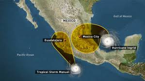 With waters rising as high as three feet (one meter) in some neighborhoods, soldiers used boats to pluck around 100 people who took refuge on upper floors or the roofs of homes. The flooding brought out crocodiles, complicating the rescue work, officials said, while Manuel’s remnants were still producing rain. Those rescued were taken to an auditorium that was converted into a shelter. At least 11 deaths were reported in Acapulco, including a family of six whose home was crushed by a landslide. “There’s no power and we are surrounded by water,” said Carlos Alvarez, who lives near a neighborhood where around 50 two-level homes were flooded. Residents used inflatable boats to evacuate around 40 people stuck on roofs, he said, complaining that neither helicopters nor troops guarding the area were not helping. Authorities are working to create an air lift in the town of Pie de la Cuesta to transport people, state Governor Angel Aguirre told Televisa television. Some 2,500 tourists were stranded at the Fairmont Hotel, according to employees there. In the northeastern state of Tamaulipas, hundreds of people were evacuated as Ingrid made landfall near the town of La Pesca and its maximum sustained winds slowed to 60 miles (95 kilometers) per hour as it moved inland, according to the US National Hurricane Center. “We have to be very alert in the northern states. It just started raining and the damage will be seen in the next few hours,” said National Water Commission head David Korenfeld. Several communities were cut off by rising waters in Tamaulipas, while authorities rescued two power company workers whose truck was dragged away by a swollen river. –Space Daily
End.
>>>
1000 tons of polluted Fukushima rain water dumped into the sea

September 17, 2013 – JAPAN – The operator of the leaking Fukushima nuclear plant said Tuesday that it dumped more than 1,000 tons of polluted water into the sea after a typhoon raked the facility. Typhoon Man-yi smashed into Japan on Monday, bringing with it heavy rain that caused flooding in some parts of the country, including the ancient city of Kyoto. The rain also lashed near the broken plant run by Tokyo Electric Power (TEPCO), swamping enclosure walls around clusters of water tanks containing toxic water that was used to cool broken reactors. Some of the tanks were earlier found to be leaking contaminated water. “Workers measured the radioactive levels of the water collected in the enclosure walls, pumping it back into tanks when the levels were high,” said a TEPCO official. “Once finding it was mostly rain water they released it from the enclosure, because there is a limit on how much water we can store.” The utility said about 1,130 tons of water with low levels of radiation — below the 30 becquerels of strontium per liter safety limit imposed by Japanese authorities — were released into the ground. But the company also said at one site where water was found contaminated beyond the safety limit workers could not start the water pump quick enough in the torrential rain, and toxic water had leaked from the enclosure for several minutes. Strontium is a potentially cancer-causing substance that accumulates in bones if consumed. Thousands of tons of water that was poured on the reactors to tame meltdowns is being stored in temporary tanks at the plant, and TEPCO has so far revealed no clear plan for it. The problem has been worsened by leaks in some of those tanks that are believed to have seeped into groundwater and run out to sea. Separately, around 300 tons of mildly contaminated groundwater is entering the ocean every day having passed under the reactors, TEPCO says. –SBS
End.
>>>
Heavy torrential rains kill 2 in southern Ukraine

September 17, 2013 – UKRAINE – Two people were killed after heavy rains hit southern Ukraine’s Odessa region over the weekend, a local official said Monday, APA reports quoting Xinhua. The ensuing floods drowned some 4,000 farm animals and poultry, and destroyed or severely damaged more than 450 houses, causing an estimated loss of 21 million U.S. dollars, an official of the press service of Odessa regional administration told Xinhua. Around 600 residents have been evacuated in central Odessa, the worst-hit region. –APA
End.
>>>
10 dead whales wash up on Russia’s northeast Chukotka Coast

September 16, 2013 – RUSSIA – A team of Russian scientists has found the remains of 10 gray whales washed ashore in Russia’s most northeasterly region Chukotka, the Marine Mammal Council said Friday. The remains were discovered during an aerial survey of Chukotka’s Arctic coast between September 1 and 8. Stanislav Belikov, head of marine wildlife conservation at the All-Russian Research Institute for Nature Protection, said the 10 marine mammals had washed up on the 800-kilometer (500-mile) stretch of the coast. “This is quite a few, especially considering that six of these whales were washed ashore within a coastal area of 120 kilometers. They were possibly wounded by hunters or attacked by killer whales. We also shouldn’t rule out the possibility of a disease. In any case, reasons for this incident should be investigated,” Belikov said. According to the Marine Mammal Council, the number of recently deceased gray whales could be higher because not all dead whales wash up on shore. –RIA NOVOSTI
End.
>>>
Thousands flee Sumatra volcano eruption in Indonesia

September 16, 2013 – INDONESIA – Mount Sinabung erupted violently before dawn, spewing rocks and red-hot ash onto surrounding villages. Asren Nasution, head of the North Sumatra disaster agency, said more than 3,000 people within a two-mile radius had been evacuated, with no casualties reported. They are being sheltered in five wooden halls used for religious ceremonies. Several flights at Kualanamu airport, some 30 miles away in Medan, have been delayed because of the ash. Indonesia has dozens of active volcanoes, more than any other country, and straddles major tectonic fault lines known as the “Ring of Fire” between the Pacific and Indian oceans. –Sky News
End.
>>>
Sept 2, 2013
FUKUSHIMA!
Governor: Who instructed Tepco to lie for months and say Fukushima didn’t melt down? “It should have been explained there were reasons why lies had to be told” (VIDEO)
Published: September 1st, 2013 at 6:13 pm ET
Via: http://enenews.com/governor-instructed-tepco-lie-months-fukushima-didnt-melt-down-explained-reasons-lies-be-told-video
.
NBC: Up to 30 Bq/m² of Fukushima cesium to hit U.S. and Canada — Contamination transported to coast for next 6 years — Concern about impact of strontium-90 (VIDEO)
Published: September 2nd, 2013
Title: Fukushima’s radioactive ocean plume due to reach US waters in 2014
Source: NBC News
Author: Jeremy Hsu, LiveScience
Date: Aug 31, 2013
Via: http://enenews.com/nbc-up-to-30-bqm2-of-fukushima-cesium-137-to-hit-u-s-and-canada-contamination-to-go-on-for-next-6-years-concern-abotu-strontium-90-video
Remember this video report and please share
Fukushima Radiation Leakage Still Going on

Sept. 2, 2013 – FUKUSHIMA RADIATION – DISASTER GROWS
OUR PRAYERS ARE NEEDED NOW
A Twitter photo showing a “boiling sea” off the coast of Japan, near the Fukushima nuclear power plant with radiation leaks, has gone viral online. So, why is the sea ‘boiling’? The answer can be found on the NaturalNews.com report.
“After a 29-month cover-up, the Tokyo Electric Power Co (Tepco) is now calling for international help and has all but admitted Fukushima’s radiation leaks are spiraling out of control. In addition to the leaking water storage units that are unleashing hundreds of tons of radioactive water each day, Tepco now says 50% of its contaminated water filtration capability has been taken offline due to corrosion,” the news website published Tuesday.
Radiation Experts their will be an enormous amount of contamination flowing from Fukushima which will imperil the entire Pacific Ocean in the next few years. This disaster threatens other countries, harming the food chain and the ocean water and fish.
Anand Naidoo, CCTV anchor: “From what we know about what is going on at the plant right now, is this going to get worse?”
Dr. Janette Sherman, radiation expert: “I hate say this, but yes I think it will. And my concern is the enormous amount of radioactive material flowing with the water into the Pacific Ocean. And we know that the ocean flows northward along Alaska and down the coast of Canada and the United States. And I think it probably will imperil the entire Pacific Ocean, and the the sea life that’s in it..” Read full article.
.
End.
___________________________________________________________
Aug 2013
.
>>>
EARTH CHANGES

August 26, 2013 – ROME, Italy – Italian experts have been puzzled by the overnight appearance of what looks like a volcanic geyser erupting steam and gases 5 meters into the air. What appears to be a new fumarole appeared near Rome’s International Fiumicino airport Saturday morning. A vent producing small geyser-like fountains of steam, water and mud was suddenly opened in the ground near a road crossing near Fiumicino. Geologists are currently examining the phenomenon. It is still a bit unclear whether it is not a man-made accident caused by a broken pipe or similar (which might well be the case). As La Repubblica statess, first inspections however indicate that it is in fact a new natural vent. Obviously, there are also already some speculations whether it could be related to volcanic activity. The nearest possibly still active volcanic system in the area is the Monti Albani, an old but possibly not yet extinct volcanic complex located 20 km SE of the capital. Its last known activity there took place about 20,000 years ago. New volcanic activity in the suburban area of Rome itself is certainly not a completely impossible, but quite unlikely scenario. More data will be needed to shed light on this. “From Mt. Etna in Sicily up to the Alban hills around Rome, there is a good deal of volcanic activity,” Alberto Basilli, a seismologist at the Italian National Institute for Geophysics and Volcanology told the Daily Telegraph. –Volcano Discovery
>>>
.
Published on Aug 16, 2013
.
Record eruption at Japanese volcano, city covered in ash
Published time: August 19, 2013
See Full Story & video:
http://rt.com/news/volcano-japan-eruption-record-653/
Sakurajima, one of the world’s most active volcanoes, has covered the city of Kagoshima in southern Japan in ash and spewed a record-high cloud of smoke 5 kilometers into the sky.
The smoke plume was the highest since 2006, when meteorologists began storing data on smoke during eruptions from the volcano.
Sunday’s eruption was the largest at Sakurajima in decades, but the 500th recorded this year, according to Wired.com.
Lava flowed 1 kilometer from the volcano, but no injuries or damage were reported.
People living in Kagoshima, a city of 600,000 people 10 kilometers from the volcano, wore masks and raincoats, and took umbrellas to protect themselves from the hazardous ash.
 This handout picture, taken by Kagoshima Local Meteorological Observatory on August 18, 2013 shows smoke and ash rising from the 1,117-meter Mount Sakurajima at Kagoshima city in Japan’s southern island of Kyushu. (AFP/Jiji Press)
Volcanic ash causes respiratory problems and can damage eyesight. Minerals present in volcanic ash can also trigger fatal lung diseases.
Local officials seemed unfazed by the latest eruption, however.
“The smoke was a bit dramatic, but we are kind of used to it,” a city official who requested anonymity told AP.
Railway services were suspended in the city, so that ash could be removed from the tracks, and car drivers were forced to turn on their headlights as the sky went dark.
By Monday morning, the air was clearer as hundreds of rubbish trucks and sprinklers were used to cope with the aftermath. Masked residents helped sweep up the ash.
Japan’s Meteorological Agency warned that volcanic activity could continue and advised residents against approaching the volcano. However, the agency said it was not expecting any larger eruptions soon.
 Smoke rises after an eruption of Mount Sakurajima in Kagoshima, southwestern Japan, in this photo taken through a window by Kyodo August 18, 2013. (Reuters/Kyodo)
_____________________________
July 2013
Dead dolphins washing up on Virginia beaches at an alarming rate
Posted on: July 31, 2013
Update: 5 more dead dolphins wash up in Virginia; Total now at 87 for the year
Virginia Beach, Va. – Dead dolphins washed up on beaches in Virginia at an alarming rate in July.
Mark Swingle, Director of Research and Conservation at the Virginia Aquarium and Marine Science Center says the Virginia Aquarium Stranding Response Team has responded to 82 bottle-nosed dolphin strandings in 2013, with 44 of those happening in the month of July.
“An average year for us is about 65 dolphin stranding for the whole year, so we are quite far ahead of that pace,” Swingle explained. “If you go back 10 years, the average number of dolphins in a July would be about 6 or 7.”
READ More: wtkr.com
>>>
Underground fires erupting, which could mean that as the Earth continues to expand there are areas where rising magma is nearing the surface.
A potential danger, among many, is the possibility fires or magma interacting with rising methane and hydrogen sulfide gases. Many relationships and spill-over effects should be hypothesized and researched to learn and to prepare for future emergencies.
These are rational actions I ask researchers and officials to undertake. Will they increase studies and observatories with the objective to prepare for future natural disasters?
I apologize for this inconvenience and possible format disruption/confusion that may result from the deletions.
>>>

According to the US Geological Survey (USGS), the tremor occurred at 5:09 p.m. local time (0509 GMT) on Sunday, 57 kilometers (36 miles) south-southwest of the capital Wellington at a depth of 14 kilometers.
The USGS initially reported the magnitude at 6.9.
It was followed minutes later by another quake of 5.5 and came about 10 hours after a 5.8 tremor in the same region, which has been rocked by multiple quakes in recent days.
Dozens of earthquakes were recorded on Sunday.
New Zealand government geological agency GNS Science described both quakes as severe, adding that more aftershocks can be expected.
All train services around Wellington were suspended after the quakes, and TranzMetro said delays can be expected.
The Pacific Tsunami Warning Centre said earthquakes of such magnitude can generate local tsunamis but there was no threat of a “destructive widespread tsunami.”
Recent quakes have been centered about 200 kilometers north of New Zealand’s second largest city Christchurch, where a 6.3-magnitude quake on February 22, 2011 struck the cathedral city on South Island.
The natural disaster killed 181 people, destroyed thousands of houses, and left much of Christchurch’s central business district in rubble.
The country sits on the so-called Ring of Fire, the boundary of the Australian and Pacific tectonic plates, and experiences up to 15,000 tremors a year. – Source: PRESSTV
>>>
66: NASA satellite detects large plume from DR Congo’s Nyamuragira volcano

July 19, 2013 – DR CONGO, Africa – Recent NASA satellite images from 11 June 2013 show a thick steam and gas plume rising from a pit crater in the summit caldera of Nyamuragira volcano. No evidence of lava close to the surface was found, while the lava lake in neighboring Nyiragongo remains well active and visible on the same images. Nyamuragira’s plume was rich in water vapor — which condenses rapidly in the humid tropical air — and sulfur dioxide, which lends a blue tint in natural-color satellite imagery. Carbon dioxide, fluorine, and chlorine gas are also found in Nyamuragira lavas and likely present in the gas plume. Located near the eastern boundary of the Democratic Republic of the Congo, Nyamuragira is one of Africa’s most active volcanoes. If degassing magma was near the surface, then the intense heat would cause a bright red glow in shortwave infrared light. No such glow is visible atop Nyamuragira, but it is present on neighboring Nyiragongo Volcano, which has featured a lava lake for more than a decade. The images were collected on June 11, 2013, by the Operational Land Imager on Landsat 8. In natural color (top), the rainforest is dark green, clouds are white, and the sulfur-rich volcanic plume is very light blue. Barren land at Nyamuragira’s summit and lava flows is brown or black. In false-color, clouds are mostly white and volcanic plumes are cyan. Forest and other vegetation is bright green. Fresh lava flows from the 2011–12 eruption of Nyamuragira are black, and older lava flows appear as brown tendrils running down the mountain’s flanks. Agricultural fields in the southeast (lower right) corner of the image also appear brown. –Volcano Discovery
Seismic swarm near another Alaskan Volcano: A seismic swarm with magnitudes up to 3.5 has been occurring in the Wrangell Arc about 40 km NE of Mt. Churchill volcano during the past few days. The intensity and frequency of the quakes has calmed down yesterday. While some few of the quakes are near the volcano, most are not, and the swarm is probably not linked to the volcanic system of Mt Churchill volcano. Churchill is the fourth tallest volcano in the U.S. and has erupted in more than 1,300 years. –VD
>>>
Recent earthquakes in Arequipa, Peru caused by Sabancaya Volcano

July 18, 2013 – PERU – The man in charge of monitoring the Sabancaya Volcano confirmed to the Peruvian daily, El Comercio, that the recent wave of earthquakes in the Arequipa region were caused by the volcano. “We´re in the sphere of influence of the Sabancaya Volcano, so all of the earthquakes we´ve experienced in the last few days were in fact caused by the volcano,” Domingo Ramos Palomino told the daily. He went on to explain that though there has been increased activity around the Sabancaya, there is not enough evidence to predict an eruption in the near future. “We will likely continue to feel more of these earthquakes, but it takes years of activity for them to produce an eruption,” Ramos said. Ramos said that the volcano only presented alteration in physical activity, not more variations in other monitoring parameters, such as the structure’s deformation. At least 111 houses collapsed, 30 of them in Huambo, where also the drinking water supply was affected. 580 more houses were damaged, according to the Earthquake Report. The tremors started with a massive 6.0 earthquake striking north of Arequipa, in Southern Peru. Therefore, he believes there is no great change from the crisis of fumaroles that he observed in February, because they continue at an altitude of between 400 and a thousand meters. In that sense, he said that the recent earthquakes are not “a detonator that indicates that the volcano will erupt.” –Peru this Week

>>>
Massive Portugal earthquake today, would devastate much of Britain

Dangerous quake zone: The city of Lisbon was ripped open by the 1755 earthquake which left fissures 15 feet wide in the city center.
July 17, 2013 – BRITAIN – Swathes of Britain could be left totally underwater by a tsunami in the Atlantic Ocean, it has been claimed. An earthquake off Portugal could trigger disastrous levels of flooding along the coast of the UK, scientists have said. The Isles of Scilly and parts of Cornwall would be worst hit if there were a repeat of the Lisbon earthquake of 1755. Experts believe that a quake similar to the devastating one 250 years ago would send a 10ft wall of water towards the UK. The tsunami would crash over the tip of Cornwall within a few hours – leaving much of the coast underwater and wiping the tiny Scilly Isles off the map. The prospect of the natural disaster was raised at a meeting of the Devon and Cornwall Local Resilience Forum, which includes police, town planners and emergency services. Members of the LRF told the meeting they fear Britain could suffer its own version of the 2004 Boxing Day Tsunami. They want an early warning system to alert bathers and people living on the coast, similar to technology used across Asia and America. Britain was last hit by a tsunami in 1755, the year of the great Lisbon earthquake, the meeting in Bristol was told. In the event of an earthquake in the Atlantic, the public would currently rely on the British Geological Survey to register the quake and the arrival of a subsequent wave at nearby Portugal. Neil Hamlyn, LRF coordinator in Devon and Cornwall, said: ‘The Isles of Scilly could be affected greatly, the islands could be covered and disappear.’
The 1755 Lisbon earthquake almost totally destroyed Lisbon and adjoining areas and had a magnitude in the range of 8.5 on the Richter scale. Under the Civil Contingencies Act of 2004, the UK maintains a National Risk Register of Civil Emergencies. The very high risk table is currently topped by pandemic flu, terrorist attacks and coastal flooding, though the last major civil flooding emergency was on the east coast in 1953. Mr Hamlyn says a tsunami is in the top 20 of the second category of high risks. Other uniquely regional threats include a nuclear submarine incident at Devonport dockyard and possible contamination from old tin mines in Cornwall. –Daily Mail
>>>
Mysterious Manatee and Dolphin Deaths in Florida Confound Scientists
 Wired – Once a lush and healthy estuary, the Indian River Lagoon is now an enigmatic death trap. Running along 40 percent of Florida’s Atlantic coast, the lagoon’s brackish waters harbor a mysterious killer that has claimed the lives of hundreds of manatees, pelicans, and dolphins.
Nobody knows why.
In April, NOAA declared the spate of manatee deaths an Unusual Mortality Event, a designation granted when marine mammal deaths or strandings are significantly higher than normal, demand immediate attention, and are the result of a common but unknown cause. Soon, the bottlenose dolphin die-off may be given the same designation.
“We have to hope we can find the answer, because until we do, we don’t know how we can help prevent it in the future,” said Jan Landsberg, a research scientist with the Florida Fish and Wildlife Conservation Commission.
Since last July (2012-2013), 51 dolphins, 111 manatees, and as many as 300 pelicans have perished in the lagoon. The deaths don’t follow an obvious pattern: Manatees are dying so quickly that some still have food in their mouths, while the dolphins and pelicans appear to be starving to death.
Mangrove islands in the Indian River Lagoon, a treasured estuary on Florida’s eastern shore. (South Florida Water Management District)
Investigators don’t know if the die-offs are the work of the same killer, or if by some coincidence, nature has produced three unrelated carcass piles at once. The only clear link so far is the lagoon, a treasured and frail ecosystem that’s home to more than 3,500 species of plants and animals.
Scientists searching for the killer are following a long, branching trail; the story begins years ago, when a prolonged drought and cold snap set the lagoon’s resources toppling like a string of dominoes. Now, a multi-year, $3.7 million protection initiative has been adopted in an attempt to put the brakes on the lagoon’s collapse, and prevent future crashes. But its success depends on scientists uncovering the culprit behind the ecological mayhem.
Imperiled Paradise
Designated an “estuary of national significance” by the EPA in 1990, the Indian River Lagoon system stretches for 156 miles along Florida’s eastern coast. Though less than 6 feet deep on average, the lagoon is stuffed with more species of marine life than any other estuary in the continental United States. Salt marshes, mangrove swamps, oyster reefs, fish nurseries, and one of the densest sea turtle nesting sites in the western hemisphere are some of the ecological stars studding the stretch of coastline. Estimates suggest the barrier island complex brings in more than $3.7 billion each year from citrus farming, fisheries, recreation, and employment.
But there’s a darker side to the Sunshine State’s eastern oasis. Surrounded by developments, the lagoon has, for decades, been the drainage pool for leaking septic tanks, polluted streams, and storm water rich with nutrients from fertilizers. It’s a wind-driven system, and without tides to push the water around and flush it out, segments stagnate and pollutants accumulate.
Running from Ponce de Leon Inlet in the north to Jupiter Inlet in Palm Beach county, the lagoon’s waters flow into canals and through locks, twisting and pooling into three main segments: The Indian River, the Mosquito Lagoon, and the Banana River. Read more Here
>>>
US: Massive dust storm envelops southern Arizona
 The news.com – TUCSON: According to US media reports the first significant dust storm of the 2013 summer season moved up from southern Arizona but fell apart before hitting urban Phoenix.
Pinal and southwest Maricopa counties were under a dust storm warning that expired at 7 p.m.
The storm with gusty thunderstorms formed in Pima County Wednesday afternoon. By 5 p.m., the storm was sending dust into Pinal County.
Storms developed south of Casa Grande and began moving northwest closer to the Phoenix area, said a meteorologist.
Just after 5 p.m., the storm was estimated to be about 12 miles south of Casa Grande and heading toward Chandler.
The storm warning included the communities of Casa Grande, Coolidge, Florence, Gila Bend, Maricopa and Sacaton.
The warning also covered the nearby portions of Interstates 8 and 10.
The developing weather marked the first significant surge of activity of our summer thunderstorm season.
Hopes were high it would bring the potential of the first significant rain for the Valley in three months.
>>>
Mice with human chromosomes – the genetic breakthrough that could revolutionise medicine
 Independent.Co.uk – Scientists have created genetically-engineered mice with artificial human chromosomes in every cell of their bodies, as part of a series of studies showing that it may be possible to treat genetic diseases with a radically new form of gene therapy.
In one of the unpublished studies, researchers made a human artificial chromosome in the laboratory from chemical building blocks rather than chipping away at an existing human chromosome, indicating the increasingly powerful technology behind the new field of synthetic biology.
The development comes as the Government announces today that it will invest tens of millions of pounds in synthetic biology research in Britain, including an international project to construct all the 16 individual chromosomes of the yeast fungus in order to produce the first synthetic organism with a complex genome.
A synthetic yeast with man-made chromosomes could eventually be used as a platform for making new kinds of biological materials, such as antibiotics or vaccines, while human artificial chromosomes could be used to introduce healthy copies of genes into the diseased organs or tissues of people with genetic illnesses, scientists said. Full article Here
>>>
Explosive: Mexico’s Popocatepetl volcano erupts 39 times in 24-hour period

July 11, 2013 – MEXICO – Mexico’s Popocatépetl volcano is keeping up its recent activity, emitting 39 exhalations of “low to moderate magnitude” over the last 24 hours, according to El Universal. Ash, gases and steam expelled out of the volcano’s crater this morning reached well over a mile in the air, said Mexico’s National Disaster Prevention Center (Cenapred) in a statement. The lava dome on “El Popo” – the mound of viscous magma which, being extruded from the crater’s vent, dries and piles up not far from it — continued to swell. Overnight, glowing fragments expelled from the inside of the volcano could be seen on its slopes. El Universal wrote that one of the most significant emission of ash, steam and gas occurred today at 7:00 this morning. The volcano also registered tremors of “high and low frequency” as well as medium-sized micro-tremors occurring as a result of the movement of magma over the course of several hours. “El Popo,” one of several nicknames by which the Popocatépetl volcano is known by nearby residents, is located in Puebla state, about 43 miles southeast of Mexico City. With roughly 25 million people living in the region around the volcano, the Mexican Government is keeping an eye on this one. Ash from recent fits of activity in the past few weeks have reached as far as Milpa Alta, one of the southernmost boroughs of the capital. –Latin Times
>>>
Huge waves hit Chile and Peru vids 22 foot
Thursday, 11 July 2013
>>>
REMOVED VIDEO-SCAMMER
July 8, 2013: Major Quakes & Buoy Connection, Spaceweather Analysis
>>>
REMOVED VIDEO-SCAMMER
Uploaded on 30 June 2013 by Suspicious0bservers
>>>
India to investigate reports of underwater volcano near nuke plant in Kalpakkam
 June 25, 2013 – INDIA – The Atomic Energy Regulatory Board (AERB) has begun a detailed study to analyze the possible threats of an underwater volcano near the Madras Atomic Power Station (MAPS) in Kalpakkam, about 70km south of Chennai.
Confirming the presence of an underwater volcano five weeks ago, an AERB reply to an RTI query said the Geological Survey of India (GSI) has also recommended an advanced study to figure out the status of the volcano, though initial investigations did not detect any significant geological signs.
AERB said the National Institute of Oceanography (NIO), Oil and Natural Gas Corporation (ONGC) and GSI have recommended further analysis in view of an “inferred high density material intrusion of remnant magnetization based on magnetic and gravity anomalies” around the location of the volcano.
AERB had appointed these national agencies to study the possible threats and geological status of the underwater volcano after Smithsonian’s Global Volcanism Program (GVP) released a document on the reported volcano in 1757, located about 100km-110km from the Indira Gandhi Centre for Atomic Research (IGCAR), Kalpakkam.
According to GVP, a US government agency based in Washington DC studying active volcanoes and their eruptions during the last 10,000 years, says the undersea eruption of the volcano happened last on January 20, 1757, off Puducherry, resulting in the formation of a new island. However, AERB said GSI’s offshore surveys did not find any existence of an island.
Also, it added that the seismic data and wells drilled by ONGC in the vicinity did not indicate any volcanic intrusions.
In last September, V Pughazhendi and R Ramesh, two activists of the Peoples Movement for Nuclear Radiation Safety, who published a book compiling the documentary evidences of the volcano, demanded that the AERB conducts an advanced study.
The AERB study is in progress and the International Atomic Energy Agency (IAEA) insists countries should ensure safety and protection if they had built reactors without considering the effect of volcanoes in their vicinity. –Times of India
>>>
BRAZIL Speaks

June 21, 2012 – BRAZIL – Brazil’s president, Dilma Rousseff, and key ministers are to hold an emergency meeting on Friday following a night of protests that saw Rio de Janeiro and dozens of other cities echo with percussion grenades and swirl with teargas as riot police scattered the biggest demonstrations in more than two decades.
The protests were sparked last week by opposition to rising bus fares, but they have spread rapidly to encompass a range of grievances, as was evident from the placards.
“Stop corruption. Change Brazil;” “Halt evictions;” “Come to the street. It’s the only place we don’t pay taxes; “Government failure to understand education will lead to revolution.”
A vast crowd – estimated by the authorities at 300,000 and more than a million by participants – filled Rio’s streets, one of a wave of huge nationwide marches against corruption, police brutality, poor public services and excess spending on the World Cup.
As a minority of protesters threw rocks, torched cars and pulled down lamp-posts, police fired volleys of pepper spray and rubber bullets into the crowd and up onto overpasses where car drivers and bus passengers were stuck in traffic jams.
At least 40 people were injured in the city and many more elsewhere.
Simultaneous demonstrations were reported in at least 80 cities, with a total turnout that may have been close to 2 million.
An estimated 110,000 marched in São Paulo, 80,000 in Manaus, 50,000 in Recife, and 20,000 in Belo Horizonte and Salvador.
Clashes were reported in the Amazon jungle city of Belem, in Porto Alegre in the south, in Campinas north of São Paulo and in the north-eastern city of Salvador. Thirty-five people were injured in the capital Brasilia, where 30,000 people took to the streets.
In São Paulo, one man died when a frustrated car driver rammed into the crowd. Elsewhere countless people, including many journalists, were hit by rubber bullets.
The vast majority of those involved were peaceful.
Many wore Guy Fawkes masks, emulating the global Occupy campaign.
Others donned red noses – a symbol of a common complaint that people are fed up being treated as clowns.
“There are no politicians who speak for us,” said Jamaime Schmitt, an engineer. “This is not just about bus fares any more. We pay high taxes and we are a rich country, but we can’t see this in our schools, hospitals and roads.”
Many in the mostly young, middle class crowd were experiencing their first large protest.
Matheus Bizarria, who works for the NGO Action Aid, said people had reached the limit of their tolerance about longstanding problems that the Confederations Cup and World Cup have brought into focus because billions of reals have been spent on new stadiums rather than public services.
Rio is also due to host a papal visit to World Youth Day next month, and the Olympics in 2016.
“It’s totally connected to the mega-events,” Bizarria said. “People have had enough, but last year only 100 people marched against a bus price rise. There were 1,000 last week and 100,000 on Monday. Now we hope for a million.” –Guardian
…
We have been hearing reports from Brazil as of June 14th, 2013; here is but one:
http://briankellysblog.blogspot.com/2013/06/police-join-protestors-during-massive.html
Police Join Protestors During Massive Demonstration in Brazil
June 19, 2013
The second video below was shared with me this afternoon. The video is of a local Brazilian, sharing the Truth behind why the people are protesting in the media. All the reasons explained on mainstream media is propaganda. Surprise, surprise.
I just want to thank everyone for their patience as I process and recoup from my trip to the desert. I’m working on a post with a bunch of photos and some back story to illustrate some of what we experienced out in the Sahara, so it’s taking a bit more time than I had anticipated. I’m finding it very difficult to put into words what you feel in your heart. One thing I will say is that this trip changed me in more ways than I could possibly describe. If even a small dose of what we experienced out there starts bleeding into the rest of humanity…boy oh boy are we all in for a wild ride! To be continued…
In the meantime let this video be a signpost for where we are headed. I predict much more of this defecting amongst the ranks to be occurring in the days and weeks to come. I don’t know about you all but I smell a wonderful aroma of great change in the air ![]()
.
Tweet: #changebrazil
.
>>>
India floods kills 200 and leaves thousands stranded

June 21, 2012 – INDIA – Rescuers found 40 bodies floating in the River Ganges near a Hindu holy city on Friday, sending the death toll past 200 from flooding in northern India that has stranded tens of thousands of people, mostly Hindu pilgrims, since heavy monsoon rains began about a week ago.
The Indian air force dropped paratroopers, food and medicine for people trapped in up to 100 towns and villages cut off by monsoon rains and landslides in the northern Himalayas.
India’s Home Minister Sushilkumar Shinde put the official death toll in Uttrakhand state at 207, but that was expected to rise as authorities reach cut-off areas.
The 40 bodies discovered in the Ganges were near the city of Haridwar, police officer Rajiv Swaroop said. Shinde told reporters in New Delhi that 34,000 people have been evacuated so far and another 50,000 were stranded in the region.
Most are Hindu pilgrims who were visiting four revered shrines.
Uttrakhand state spokesman Amit Chandola said the rescue operation centered on evacuating nearly 27,000 people trapped in the worst-hit Kedarnath temple area — one of the holiest Hindu temples dedicated to Lord Shiva, located atop the Garhwal Himalayan range.
The temple escaped major damage, but debris covered the area around it and television images showed the bodies of pilgrims strewn around the area.
Soldiers and other workers reopened dozens of roads by building makeshift bridges, accelerating the evacuation, Chandola said. More than 2,000 vehicles carrying stranded Hindu pilgrims have moved out of the area since late Thursday, he said.
Thousands of soldiers continued efforts to reach the worst-hit towns and villages, Chandola said.
Rakesh Sharma, a state official, said the death toll might run into the thousands, but the exact figure will not be known until the entire region is checked.
The flooding washed away roads and nearly two dozen bridges, demolished 365 houses and partially damaged 275 others in Uttrakhand, the state government said.
An additional 17 people died in collapsed homes in neighboring Uttar Pradesh state, said R.L. Vishwakarma, a state police officer.
Thirty-six air force helicopters have been ferrying rescue workers, doctors, equipment, food and medicine to Kedarnath, the town closest to many of those stranded, said Priya Joshi, an air force spokeswoman.
Another seven aircraft carried paratroopers and fuel to the region.
On Friday, hundreds of people looking for relatives demonstrated in Dehradun, the Uttrakhand state capital, where flood survivors were taken by helicopters.
They complained that the government was taking too long to evacuate the survivors, with small helicopters bringing in four to five people at a time.
The annual monsoon rains sustain India’s agriculture but also cause flooding that routinely claims lives and damages property. –ABC News
>>>
Calgary flooding could force up to 100,000 from homes

June 21, 2012 – CANADA – As many as 100,000 residents of Calgary, Alberta, could face evacuation because of flooding, the director of emergency management said early Friday.
Mandatory evacuation orders have been issued for 20 communities, Bruce Burrell said.
Parts of southern Alberta face rising floodwaters and the possibility of more rain. The levels of the Bow and Elbow rivers are expected to peak overnight, but not drop until late Saturday at the earliest, he said. “I have never experienced any flooding of this magnitude,” he added.
There have been no initial reports of deaths or injuries. Canadian Prime Minister Stephen Harper said military assets, including helicopters, have been deployed to assist local emergency officials with rescue and evacuation efforts.
“Our thoughts and prayers are with those families who have been affected by the serious flooding in Calgary and Southern Alberta,” Harper said, adding that “any and all possible assistance” would be provided by the federal government.
A state of emergency was in effect for Calgary, according to a news release from the city.
Police and fire officials were driving through communities, broadcasting the evacuation order over loudspeakers.
Residents were being asked to mark their homes with an “X” to indicate they had evacuated.
The news release said the level of the Elbow and Bow Rivers had risen significantly. –CNN
>>>
Worst to come? doomsday poll: 87% risk of stock crash by year-end
The Fed is dropping subtle hints the thrill ride of printing money to inflate equity markets has reached its foreseeable end.
June 21, 2012 – ECONOMY – In “Stocks for the Long Run,” economist Jeremy Siegel researched all the “big market moves” between 1801 and 2001.
Bottom line: 75% of the time, there is no rationale for “big moves.”
No one can predict them.
Maybe technicians and traders can pick short-term moves the next second.
Maybe tomorrow.
But the long-term “big market moves?” No way.
Now why predict an “87%” chance of another meltdown in 2013?
Because in the real world of statistical probabilities, historical facts and expert opinions danger signals are flashing wild.
In mid-2008 we summarized the predictions of 20 experts over several years. Predicted a meltdown in a few years — markets crashed two months later. Fast.
In retrospect, it was inevitable, thanks in part to the hype, arrogance and incompetence of Fed Chairman Ben Bernanke and Treasury Secretary Henry Paulson who failed to prepare America.
The warnings are again accelerating. And so is the happy talk from Wall Street casino insiders, about rallies, housing recoveries, perpetual cheap money.
Don’t listen.
The next crash will happen by year-end.
Yes, there’s a 13% chance the next Fed chairman will keep printing cheap money into 2014.
But on New Years Eve our aging bull will be 4½ years old, well past Bill O’Neill’s “average” 3.75 years for putting this bull out to pasture.
So unless you’re shorting, all bets on Wall Street casinos for 2014 are megarisk, like 2008.
Like a Stephen King horror film, you feel it coming. Could happen anytime, even tomorrow, says Siegel’s research, or the unpredictable logic in Nassim Taleb’s “Black Swan.” –Market Watch
>>>
back to the top of this page

China, India, Pakistan boost nuclear arsenals, as tensions in SE Asia increase
June 3, 2013 – CONFLICT –
Three of the world’s nuclear powers — China, India and Pakistan —
have increased their arsenals over the past year, while the other five have cut their strength or kept it stable, the Stockholm International Peace Research Institute said Monday.
China now has 250 nuclear warheads against 240 in 2012, while Pakistan has increased its warheads by about 10 to between 100 and 120 and India has also added roughly 10 for a total of 90 to 110, SIPRI said in its annual report.
According to SIPRI, the arms race is all the more disturbing because of what the institute called a “fragile” peace in Asia, characterized by growing tensions since 2008 between India and Pakistan, China and Japan, and the two Koreas, among others.
“While states have avoided direct conflict with each other and have stopped supporting insurgent movements on each other’s territory, decades-old suspicions linger and economic integration has not been followed up with political integration,” SIPRI said.
Only the two old superpowers have cut their warheads, Russia reducing its number from 10,000 to 8,500, and the United States scaling back from 8,000 to 7,700.
The warheads controlled by France stayed at 300, while Britain’s remained at 225, and Israel’s at 80.
SIPRI acknowledged that the figures were, to a large extent estimates, as the nuclear powers aren’t equally transparent, China being totally opaque, and Russia gradually becoming less open SIPRI does not count North Korea and Iran as nuclear powers yet, as their respective programs are still considered in their early stages.
While the global total of warheads was down, SIPRI said it did not translate into a significantly diminished nuclear threat.
“Once again there was little to inspire hope that the nuclear weapon-possessing states are genuinely willing to give up their nuclear arsenals.
The long-term modernization programs under way in these states suggest that nuclear weapons are still a marker of international status and power,” said SIPRI Senior Researcher Shannon Kile.
Efforts to reduce arsenals of chemical and biological weapons have also been slow, according to SIPRI, a long-time advocate of abolishing weapons of mass destruction.
The United States and Russia have not destroyed all their chemical weapons in 2012 as promised, and Syria has said it is prepared to use them in the case of foreign attack.
SIPRI figures also show that the number of peacekeepers deployed around the world fell by more than 10 percent in 2012, reflecting partly the beginning withdrawal of international forces from Afghanistan.
SIPRI noted an increase in recent years in the number of intrastate conflicts that are internationalized, as outside states have supported one side or another. –France 24
>>>
Snow in June: Russia’s Siberian town in absolute anomaly
Posted on June 3, 2013
June 3, 2013 – SIBERIA – A layer of snow on the second day of summer has put the citizens of the Russian city of Kemerovo completely out of humor.
Meteorologists say the anomaly occurred because a cyclone brought cold Arctic air from Kara Sea region into Siberia dropping, temperature to lows typical for summer north of the Arctic Circle.
Bloggers were at a loss when commenting the issue.
“Snow in Kemerovo TODAY? That’s hardcore. The weather must’ve forgot it’s June.”
“With a sense of terror has just learnt it’s been snowing in Kemerovo. What’s next?”
And, “Tornado in the US. Floods in Czech Republic. SNOW in Kemerovo!”
The city in South Siberia is situated on 55°22’17.58″ north latitude but even for that region -2 Celsius on June 2 morning is over the top.
The region has seasonal inland climate, which means really cold winters and very hot summers.
This spring has been sort of cold in the Kemerovo Region, which witnessed snow in early May and an emergency extension of the heating season.
No wonder that people have been waiting for warm summer days just like for manna from heaven, but instead got snowflakes.
But the locals are full of determination to recalculate sowing season schedule and plant kitchen gardens as usual and against all odds, probably because over 70 percent of Russia’s territory is the area of risk farming and people are used to encounter hardships of the kind. –RT News
>>>
Central Europe hit by major floods
Aljazeera.com – 6/3/13
Several killed or missing in Germany, Czech Republic and Austria after torrential rain causes flooding and mudslides.
Authorities in parts of Europe issued disaster warnings and scrambled to reinforce flood defences as rivers swelled by days of heavy rain threatened to burst their banks.
Several people have died or are missing in the floods in Germany, the Czech Republic, Austria, and Switzerland since the rains began on Thursday.
>>>
Southern hemisphere: New Zealand told to brace for wild weather


The Extinction Protocol, 6/3/13
http://peoplestrusttoronto.wordpress.com/2013/06/03/southern-hemisphere-new-zealand-told-to-brace-for-wild-weather/
June 3, 2013 – NEW ZEALAND – MetService has issued severe weather watches for parts of the country.
Westland, Buller, Nelson, Marlborough, Canterbury, Wellington, Wairarapa, Bay of Plenty and Rotorua are among the regions set to face heavy rain and wild weather over the next 24 hours.
Pictures sent to ONE News show heavy snow has been causing disruptions for motorists on the last day of the long weekend.
Vehicles with chains waited for hours this afternoon for roads to open in Burkes Pass, just north of Tekapo. Eight firefighters in the area were called to push at least half a dozen cars out of the snow and assist police with road control, Volunteer Fire Chief Officer Craig Willis said.
MetService says there is a high possibility of heavy snow in North Canterbury and Marlborough tomorrow as the cold southerly rain turns into snow above 400 meters.
Heavy rain and gales are expected for central New Zealand tomorrow as a front is expected to move slowly across the upper South Island and lower North Island.
Snow of about 500 meters is predicted for Hanmer Springs and Seddon areas. As of early evening, there had been no deaths on the road this long weekend, putting the country on track to achieving the first zero road toll over the Queen’s Birthday Holiday since records began.
But with snow and flooding in many southern areas, police are warning motorists to take extra care. -TVNZ
>>>
http://www.volcanodiscovery.com/photo-of-the-month/2013-jun.html
 (Photo: Martin Rietze)")
Photo of the Month
|
July
|
August
|
||
|
September
|
October
|
November
|
December
|
 (Photo: Richard Roscoe)")
 [?]
[?]")
")
")
")
 (Photo: Martin Rietze)")

>>>
Earthquake Report for 06/01/2013
http://pepcoconnect.files.wordpress.com/2010/07/earthquake1.jpg
By: USGS, 06/01/2013

29 earthquakes
2.8 6km W of Greenville, California 2013-06-01 14:56:49 UTC-04:00 3.8 km
4.6 201km E of Namie, Japan 2013-06-01 14:05:19 UTC-04:00 9.9 km
2.6 57km WSW of Cantwell, Alaska 2013-06-01 14:05:12 UTC-04:00 99.7 km
5.5 84km WSW of Chirovanga, Solomon Islands 2013-06-01 13:32:51 UTC-04:00 70.5 km
4.6 84km ENE of Diego de Almagro, Chile 2013-06-01 12:50:52 UTC-04:00 19.5 km
4.8 31km WSW of Darapidap, Philippines 2013-06-01 12:35:38 UTC-04:00 43.4 km
4.9 25km ESE of Lata, Solomon Islands 2013-06-01 12:25:35 UTC-04:00 56.4 km
3.2 45km SSE of Lone Pine, California 2013-06-01 11:06:01 UTC-04:00 0.1 km
3.5 53km N of Valdez, Alaska 2013-06-01 10:51:59 UTC-04:00 25.2 km
4.9 10km NNE of President Roxas, Philippines 2013-06-01 10:40:23 UTC-04:00 43.6 km
5.6 5km ENE of Carmen, Philippines 2013-06-01 10:10:07 UTC-04:00 16.0 km
4.5 195km ENE of Nord, Greenland 2013-06-01 10:06:52 UTC-04:00 10.0 km
4.8 33km WNW of Tor, Egypt 2013-06-01 07:49:27 UTC-04:00 10.0 km
2.7 14km WNW of Greenville, California 2013-06-01 07:43:03 UTC-04:00 0.0 km
4.3 51km SW of Kushiro, Japan 2013-06-01 03:54:11 UTC-04:00 93.9 km
4.7 9km SW of Lata, Solomon Islands 2013-06-01 03:32:32 UTC-04:00 10.3 km
4.7 Off the coast of Aisen, Chile 2013-06-01 03:21:33 UTC-04:00 10.1 km
3.1 103km NNW of Road Town, British Virgin Islands 2013-06-01 03:03:51 UTC-04:00 38.0 km
4.0 3km ENE of San Pedro, Colombia 2013-06-01 02:44:27 UTC-04:00 115.7 km
4.4 87km NNE of Punta Cana, Dominican Republic 2013-06-01 01:48:42 UTC-04:00 23.0 km
5.1 15km E of San Policarpo, Philippines 2013-06-01 01:17:29 UTC-04:00 64.3 km
4.3 57km SSW of La Gomera, Guatemala 2013-06-01 00:36:26 UTC-04:00 42.7 km
3.3 57km SE of Boca de Yuma, Dominican Republic 2013-06-01 00:20:01 UTC-04:00 100.0 km
5.3 295km SW of Vaini, Tonga 2013-05-31 21:34:15 UTC-04:00 184.1 km
2.9 10km ENE of Washington, Utah 2013-05-31 18:45:33 UTC-04:00 3.2 km
2.8 9km ENE of Washington, Utah 2013-05-31 18:34:26 UTC-04:00 3.4 km
4.4 232km WNW of Farallon de Pajaros, Northern Mariana Islands 2013-05-31 18:21:55 UTC-04:00 321.0 km
2.5 8km S of Princeton, Canada 2013-05-31 17:29:41 UTC-04:00 0.0 km
2.9 77km N of Road Town, British Virgin Islands 2013-05-31 17:17:51 UTC-04:00 36.0 km
Vía The Galactic Free Press – Your Multi-Dimensional Newspaper http://soundofheart.org/galacticfreepress/content/earthquake-report-06012013
>>>
Pacaya volcano erupts in Guatemala

May 31, 2013 – GUATEMALA – Guatemala’s Pacaya volcano has erupted, authorities said. Sending volcanic material more than 400 meters in the air, the eruption could intensify with ash risiging as high as 1000 to 2000 meters, the Institute of Vulcanology said. This could pose a threat to Guatemala’s air traffic. “Ash could spread over Guatemala City due to the direction of the wind,” the country’s disaster response office said in a statement. The last major eruption of the 2552 metre-high Pacaya was in May 2010 and claimed the life of a television journalist. Thousands of people fled from their homes and the eruption forced the closure of the Guatemala City airport for five days. The volcano is located 50 kilometres south of the capital and is one of three active volcanoes in Guatemala. –TVNZ
>>>
The Colorado River, the High Plains aquifer and the entire Western half of the U.S. are rapidly drying up

May 25, 2013 – COLORADO – What is life going to look like as our precious water resources become increasingly strained and the western half of the United States becomes bone dry? Scientists tell us that the 20th century was the wettest century in the western half of the country in 1000 years, and now things appear to be reverting to their normal historical patterns. But we have built teeming cities in the desert such as Phoenix and Las Vegas that support millions of people. Cities all over the Southwest continue to grow even as the Colorado River, Lake Mead and the High Plains Aquifer system run dry. So what are we going to do when there isn’t enough water to irrigate our crops or run through our water systems? Already we are seeing some ominous signs that Dust Bowl conditions are starting to return to the region. In the past couple of years we have seen giant dust storms known as “haboobs” roll through Phoenix, and 6 of the 10 worst years for wildfires ever recorded in the United States have all come since the year 2000. In fact, according to the Los Angeles Times, “the average number of fires larger than 1,000 acres in a year has nearly quadrupled in Arizona and Idaho and has doubled in every other Western state” since the 1970s. But scientists are warning that they expect the western United States to become much drier than it is now. What will the western half of the country look like once that happens? In a recent National Geographic article contained the following chilling statement…The wet 20th century, the wettest of the past millennium, the century when Americans built an incredible civilization in the desert, is over. Much of the western half of the country has historically been a desolate wasteland. We were very blessed to enjoy very wet conditions for most of the last century, but now that era appears to be over. To compensate, we are putting a tremendous burden on our fresh water resources. In particular, the Colorado River is becoming increasingly strained.
Ecosystem crash: Without the Colorado River, many of our largest cities simply would not be able to function. The following is from a recent Stratfor article: “The Colorado River provides water for irrigation of roughly 15 percent of the crops in the United States, including vegetables, fruits, cotton, alfalfa and hay. It also provides municipal water supplies for large cities, such as Phoenix, Tucson, Los Angeles, San Diego and Las Vegas, accounting for more than half of the water supply in many of these areas.” In particular, water levels in Lake Mead (which supplies most of the water for Las Vegas) have fallen dramatically over the past decade or so. The following is an excerpt from an article posted on Smithsonian: “And boaters still roar across Nevada and Arizona’s Lake Mead, 110 miles long and formed by the Hoover Dam. But at the lake’s edge they can see lines in the rock walls, distinct as bathtub rings, showing the water level far lower than it once was—some 130 feet lower, as it happens, since 2000. Water resource officials say some of the reservoirs fed by the river will never be full again.” Today, Lake Mead supplies approximately 85 percent of the water that Las Vegas uses, and since 1998 the water level in Lake Mead has dropped by about 5.6 trillion gallons. –TECB
>>>

May 24, 2013 – CHILE – SERNAGEOMIN has raised the alert level to orange. Since May 15, a progressive increase in seismic activity as well emissions of gas and now some ash have been observed. Both earthquakes related to rock fracturing and fluid movements have picked up in numbers and possibly indicate a new magmatic intrusion on its way. This scenario is confirmed by the start of small ash emissions and glow at the crater which is visible at night. The plume of gas and ash could be seen from space by the MODIS sensor, stretching about 100 km to the southeast. Copahue volcano had already experienced a first increase of activity in December, and a second one in January. No eruption followed and alert was lowered to green in April before returning to yellow again soon after. –Volcano Discovery
>>>

May 23, 2013 – CHINA – Five people have died after a 10-metre wide sinkhole opened up at the gates of an industrial estate in Shenzhen, the southern Chinese boom town neighboring Hong Kong. The Shenzhen Longgang district government said on its verified page on Sina Weibo, China’s version of Twitter that five people had died and added that it was investigating the incident. The sinkhole formed just outside the Huamao Industrial Park in Shenzhen on Monday evening, at a time when many factory workers would have been changing shifts, according to the website of Beijing-based newspaper the Guangming Daily. The state-run Shanghai Daily newspaper said that rescuers saved one man. Reports said it was unclear how many people had fallen into the hole in total, but the search was continuing on Tuesday. Sinkholes in China are often blamed on construction works and the country’s rapid pace of development. Surveillance cameras in March captured images of a security guard being swallowed by a sinkhole, also in Shenzhen. Two months ago a man was killed when his bedroom was swallowed by a eight meter sinkhole in Florida, in the US. –Herald Sun
>>>
Incomprehensible destruction: Authorities lower death toll to 24; number of injured hits 240, including 60 kids

May 21, 2013 – OKLAHOMA – Rescuers searched frantically for survivors Tuesday as the death toll from the massive tornado that leveled suburban Oklahoma City was dropped to 24. The sharp decline from the original fatality list of 51 names was likely caused by double counting of victims, authorities said. “We have got good news. The number right now is 24,” said Amy Elliott, chief administrative officer at the Oklahoma City Medical Examiner’s Office. She blamed the earlier high estimate on the large amount of “chaos” in the wake of the twister. All but three of the bodies recovered have been identified and are being returned to their families, she said. The number of injured was placed at 240, with 60 of them being children. The National Weather Service gave a preliminary ranking of EF4 to the twister, meaning it is the second-most powerful type of tornado, with winds up to 200 mph. The devastating storm struck Monday, and by late that night, 51 people were said to be dead and some two dozen children missing. Whole neighborhoods were flattened, families shattered and loved ones unaccounted for in the chaos of wind-scattered debris. Rescue workers combed through the wreckage of two elementary schools as darkness covered destroyed communities. –NY Daily News

>>>

May 19, 2013 – ANCHORAGE – Alaska’s remote Pavlof Volcano has been shooting lava hundreds of feet into the air, but its ash plume is thinning and is no longer making it dangerous for airplanes to fly nearby. Geologist Chris Waythomas of the Alaska Volcano Observatory says a narrow ash plume extends a couple hundred miles southeast from the volcano, which is 625 miles southwest of Anchorage. The eruption that began Monday seemed to be slowing on Saturday, but Waythomas says that could change at any time. He says seismic tremors from the 8,262-foot volcano have been going up and down, but remain at a fairly high level. Scientists are not expecting the eruption to end anytime soon but so far it has not been explosive. There are mud flows racing down the summit, but no one lives close enough to the volcano to be threatened. –ABC News
>>>
4.0 earthquake rattles residents in Los Angeles, California
May 17, 2013 – LOS ANGELES, CA. – The Southern California coastline felt a “real good jolt” yesterday at about 1 p.m. A 4.0 magnitude earthquake rumbled just off the coast of the Palos Verdes Peninsula.
>>>
May 14, 2013
lava flows detected on 2 Alaska volcanoes
ANCHORAGE, Alaska (AP) — Scientists say small lava flows have been detected on two restless volcanoes in Alaska.
The Alaska Volcano Observatory says satellite images Tuesday show the lava partly down a flank of Pavlof Volcano in a low-level eruption 625 miles southwest of Anchorage.
Geophysicist Dave Schneider says minor steam and ash emissions are visible from the community of Cold Bay 37 miles away.
Pavlof is the second Alaska volcano to erupt this month.
Cleveland Volcano, on an uninhabited island in the Aleutian Islands, experienced a low-level eruption in early May. The observatory says analysis of satellite imagery shows a lava flow partly down a flank of the volcano.
Ash plumes can be an aviation hazard, but no ash clouds have been detected from Cleveland Volcano in the past week.
>>>
Massive underwater volcano discovered off the coast of southeast Alasksa
Massive underwater volcano discovered off the coast of southeast Alasksa
U.S. Forest Service Geologist Jim Baichtal, who is based on Prince of Wales Island, and Anchorage geologist Sue Karl were looking at some hydrographic surveys, something geologists tend to do. When we were done, I noticed the area from Thorne Arm to Rudyerd had been surveyed,” Baichtal said. “I zoomed in and there was this large… some kind of volcano, and two other dome-like structures.” Karl added that, “This new NOAA survey allowed us to see things that people had never seen before.” Karl said a modern example of a similar eruption is Surtsey, a volcanic island in Iceland, which erupted from the sea floor in the 1960s, building itself up and eventually breaching the surface to form the island. Karl points out that when the newly discovered volcano erupted, sea levels also were lower than they are now, but even with that, “We still have too much depth. We have to call on glacial loading and rebound.” “When you get a thousand feet of ice sitting on the ground, it is very heavy,” she explains. “It actually depresses the earth’s crust. After the glacier melts back, the earth will rebound.” Like a trampoline, or waterbed, but at a much slower pace. “So at one time, in Misty Fiords, there was close to 4,000 foot of ice on that site, so the weight of that ice at least pushed down (created) as high as 400 feet of displacement,” Baichtal added. So, in summary, the volcano erupted within the last 13,000 years, after the ice retreated, as the land was slowly bouncing back, and when sea levels were lower. They figured out most of this stuff just from examining the surveys. Volcanoes show up along faults in the earth’s crust, so when the fault moves enough to expose magma, that can lead to a volcanic eruption. Since faults don’t go away, volcanic eruptions in Southeast Alaska are possible in the future. “With the evidence that we have and the geologic age of the things that are there, there is no reason why it couldn’t,” he said. “I wouldn’t be surprised if it did.” But, Karl said people shouldn’t get anxious about it. “We have much better technology for detecting the initiation of one of these sorts of things now,” she said. “I don’t think people need to get too worried.” The newly discovered volcano is very close to New Eddystone Rock, which is what’s left over from another volcano, which may have erupted around the same time frame. They are both near the entrance to Misty Fiords National Monument. –KRBD
___________________________________________________________
Quake threat on Arabian Sea coast more real than thought
Charu Sudan Kasturi, Hindustan Times New Delhi, May 15, 2013
http://www.hindustantimes.com/India-news/NewDelhi/Quake-threat-on-Arabian-Sea-coast-more-real-than-thought/Article1-1060225.aspx
Undersea earthquakes as strong as the 2004 Sumatra temblor that spawned a tsunami killing over 220,000 could also strike under the Arabian Sea, off the coast of Pakistan and Iran, striking those countries, India, Oman and further inland, a team of British and Canadian scientists has said.
India’s Arabian Sea coast is home to the 1400 MW Tarapur Power Station near Mumbai, India’s largest operational nuclear plant that in 2011 was also identified by a government expert panel as the least prepared of the country’s atomic power complexes to handle a scenario like the one at Fukushima in Japan in 2011.
The country is also in the process of setting up a 10,000 MW nuclear power complex at Jaitapur that has faced local opposition.
But though the subduction zone – where tectonic plates meet – to India’s west, near Makran along the Pakistan-Iran border is closer to India than the one to the east that was the epicentre of the 2004 tremors, the Arabian Sea has long been considered less vulnerable to large earthquakes and tsunamis.
Unlike the Pacific Ocean and the eastern Indian Ocean, where giant undersea earthquakes are common, the Makran region has been largely quiet after a 7.3 magnitude tremor in 1947.
 That view may be dangerously complacent and incorrect, scientists at the University of Southampton, UK and the Canadian government’s Pacific Geoscience Centre have suggested in their research, published in reputed journal Geophysical Research Letters.
>>>

http://www.dailymail.co.uk/news/article-2324803/UK-weather-Snow-falls-amid-65mph-winds-town-gets-month-rain-just-24-hours.html
May 15, 2013
– UNITED KINGDOM – It’s beginning to look a lot like Christmas – so it’s rather odd that we find ourselves in mid-May. Snow fell across parts of Britain last night while another area had a month’s rain in just 24 hours as winds of up to 65mph battered the country’s coastlines in unusual weather for the month. Up to 3in of snow fell in Princetown in Dartmoor, Devon, Rhayader in Powys, and Newcastle-on-Clun in Shropshire – while Pembrey, Carmarthenshire, had 3in of rain in the 24 hours until 7am today. Local woman Sheila Coates told BBC Radio Devon: ‘It’s crazy. Last night I couldn’t see out of my front window for the snow. I’ve lived here all my life, and I’ve never known weather like it at this time of year.’ Up to 3in of snow also fell on high ground in the rural county of Shropshire last night – sparking fears of flooding in the rest of the region, as two local rivers were given flood warnings. Mike Steedman, owner of the Anchor Inn in the hills above Newcastle-on-Clun, near the Welsh border, said. ‘It started at about 11pm and it came in wet and heavy. It’s beginning to go now. And ramblers and cyclists got more than they bargained for when snow lashed the Pennines in Cumbria as sunny May weather suddenly turned into something you would expect in January. The southern coast was hit hardest last night with police in Devon and Cornwall reporting slates coming off roofs and trees blocking roads, as rain lashed across much of the country. In Devon and Cornwall hundreds of homes were left without electricity. Residents were also bracing themselves for floods – with 14 separate alerts in place across the two counties. The Isles of Scilly bore the brunt of the Atlantic gales but freak snow flurries were reported in Exmoor and Dartmoor, where residents said the conditions were more like mid-winter than May. –Daily Mail
___________________________________________________________

Yellowstone’s Volcano Bigger Than Thought
By Becky Oskin, OurAmazingPlanet Staff Writer | LiveScience.com – Thu, Apr 18, 2013
SALT LAKE CITY — Yellowstone’s underground volcanic plumbing is bigger and better connected than scientists thought, researchers reported here today (April 17) at the Seismological Society of America’s annual meeting.
“We are getting a much better understanding of the volcanic system of Yellowstone,” said Jamie Farrell, a seismology graduate student at the University of Utah. “The magma reservoir is at least 50 percent larger than previously imaged.”
Knowing the volume of molten magma beneath Yellowstone is important for estimating the size of future eruptions, Farrell told OurAmazingPlanet.
Supervolcano trail
Geologists believe Yellowstone sits over a hotspot, a plume of superheated rock rising from Earth’s mantle. As North America slowly drifted over the hotspot, the Yellowstone plume punched through the continent’s crust, leaving a bread-crumb-like trail of calderas created by massive volcanic eruptions along Idaho’s Snake River Plain, leading straight to Yellowstone. The last caldera eruption was 640,000 years ago. Smaller eruptions occurred in between and after the big blasts, most recently about 70,000 years ago. [Infographic: Geology of Yellowstone]
The magma chamber seen in the new study fed these smaller eruptions and is the source of the park’s amazing hydrothermal springs and geysers. It also creates the surface uplift seen in the park, said Bob Smith, a seismologist at the University of Utah and author of a related study presented at the meeting.
The volcanic plume of partly molten rock that feeds the Yellowstone supervolcano. Yellow and red indicate higher conductivity, green and blue indicate lower conductivity. Made by University of Utah geophysicists and computer scientists, this is the first large-scale ‘geoelectric’ image of the Yellowstone hotspot.
“This crustal magma body is a little dimple that creates the uplift,” Smith said. “It’s like putting your finger under a rubber membrane and pushing it up and the sides expand.”
Clearer picture
A clearer picture of Yellowstone’s shallow magma chamber emerged from earthquakes, whose waves change speed when they travel through molten or solid rock. Farrell analyzed nearby earthquakes to build a picture of the magma chamber.
The underground magma resembles a mutant banana, with a knobby, bulbous end poking up toward the northeast corner of Yellowstone National Park, and the rest of the tubular fruit angling shallowly southwest. It’s a single connected chamber, about 37 miles (60 kilometers) long, 18 miles (30 km) wide, and 3 to 7 miles (5 to 12 km) deep.
Previously, researchers had thought the magma beneath Yellowstone was in separate blobs, not a continuous pocket.
The shallowest magma, in the northeast, also matches up with the park’s most intense hydrothermal activity, Farrell said. The new study is the best view yet of this zone, which lies outside the youngest caldera rim.
Additional molten rock, not imaged in this study, also exists deeper beneath Yellowstone, scientists think.
___________________________________________________________
Large sinkhole swallows three cars in Chicago
April 18, 2013 – CHICAGO, IL – One person was hospitalized after a sinkhole swallowed three cars in the South Deering neighborhood on the Southeast Side this morning. The person was taken to Northwestern Memorial Hospital in serious-to-critical condition, according to the Chicago Fire Department. Witnesses said the hole opened up around 5 a.m. at 9600 South Houston Avenue, quickly growing from about 20 feet to about 40 feet. First two cars slid in, then a third as the hole widened, witnesses said. A fourth vehicle was towed from the edge as it was about to fall inside, witnesses said. The man who was injured was trying to drive his car around the hole when the road gave way, according to witnesses. The man suffered minor head injuries. Ola Oni said she was about to leave for work at 5 a.m. but had not gotten in her car yet when it suddenly fell into the hole. “It could have happened to me, I am lucky, I’m happy,” Oni said. “In this kind of neighborhood, I don’t think this should happen.” She gestured toward the hole. “Look at this, this neighborhood is in danger.” The sinkhole opened up after a water main broke, according to Tom LaPorte, spokesman for the Water Department. The heavy rain could have contributed to the break of the cast iron pipe that dates back to 1915, he said. Officials are looking at the age of the main as well as weather conditions. –Chicago Tribune
contribution by Robert M.
___________________________________________________________


.
‘Like a nuclear bomb’ – Deadly fertilizer plant blast devastates Texas town; at least 15 dead
April 18, 2013 – WACO, TX – As the sun rose Thursday over West, Texas, the scope of the small town’s devastation came into fuller view: a gruesome, bloody scene, homes flattened to rubble, and scores of firefighters battling a raging blaze. The massive, deadly blast at a fertilizer plant Wednesday night forced the evacuation of about half the town of about 2,800 people and left officials asking key questions: Was it a crime or an accident? How could it have happened? “Nothing at this point indicates we have had criminal activity, but we are not ruling that out,” said Sgt. William Patrick Swanton of the nearby Waco Police Department. A more immediate question is how high the death toll will rise. It could be between five and 15, Swanton said. Dr. George Smith, the city’s emergency management system director, said it could spike to 60 or 70. The mayor in Texas said it was, ‘like a nuclear bomb.’ “We have two EMS personnel that are dead for sure, and there may be three firefighters that are dead,” Smith said. “There are a lot of people that will not be here tomorrow,” Mayor Tommy Muska warned late Wednesday. The Texas National Guard has sent 21 troops from a civil support team to monitor air quality near the blast, the Pentagon announced Thursday. The White House said it is monitoring the situation through FEMA, which is in touch with state and local authorities. Federal authorities stand ready to help, a FEMA official said. More than 160 people were injured when the explosion shook homes as far as 50 miles away. It measured as a 2.1-magnitude seismic event, according to the United States Geological Survey. “It’s over-whelming to us,” Smith told CNN affiliate KCEN, with blood spattered all over his face from injuries he suffered. The town has only three ambulances, he said. Between 50 and 60 homes in a five-block area suffered damage, officials said. The explosion rocked the West Fertilizer Co. at about 7:50 p.m. (8:50 p.m. ET). Patients were rushed to several hospitals. Hillcrest Baptist Medical Center reported five patients in intensive care — two in critical condition, three in serious condition. At least 28 patients will be admitted, said hospital Chief Glenn Robinson. About half the community was evacuated, Muska said. “It was like a nuclear bomb went off,” he said of the blast. “Big old mushroom cloud. (It’s) massive — just like Iraq. Just like the Murrah (Federal) Building in Oklahoma City,” said D.L. Wilson of the Texas public safety department. The blast stripped a nearby apartment complex, with 50 units, of its walls and windows. “It was just a skeleton standing up,” Wilson said. A nursing home, with 133 residents, was quickly evacuated. A middle school also is located near the plant.
For sharing this my Thanks to:
‘Like a nuclear bomb’ – Deadly fertilizer plant blast devastates Texas town; at least 15 dead
___________________________________________________________
http://www.sltrib.com/sltrib/news/56173903-78/birds-dugway-monday-ground.html.csp
More than 12,000 birds crashed in Utah’s west desert Monday
The Salt Lake Tribune First Published Apr 17 2013
The number of eared grebes rescued — and killed — after their Monday crash-landings at the U.S. Army’s Dugway Proving Ground was far higher than originally estimated.
Wildlife biologists and volunteers spent Monday and Tuesday gathering 12,800 water birds, carrying the 7,828 surviving birds by pickup trucks to ponds in the region.
The birds were migrating back to the Great Salt Lake for the summer, but apparently became disoriented by snow and fog and mistook wet roads and parking lots for water. Built for water, with legs far to the back of their bodies, they can lift off from the ground only with great difficulty.
An estimated 100 birds were taken to rehabilitation facilities, Dugway spokeswoman Paula Thomas said.
Biologists working under a permit from the U.S. Fish and Wildlife Service were burning and burying the birds that died or were so seriously injured they had to be euthanized.
__________________________________

Tue Apr 16, 2013
(Reuters) – An Iranian government official said on Tuesday he expected hundreds of deaths from a major earthquake that struck Iran near the border with Pakistan.
“It was the biggest earthquake in Iran in 40 years and we are expecting hundreds of dead,” said the official, who spoke on condition of anonymity.
It was the second big quake to hit Iran in a week. On April 9, a powerful 6.3 magnitude quake struck close to Iran’s only nuclear power station, killing 37 people, injuring 850 and devastating two villages.
Read Full Report: http://in.reuters.com/article/2013/04/16/iran-earthquake-idINDEE93F07320130416
__________________________________
recently more sinkholes have been reported in Florida:
* http://www.reuters.com/article/2013/03/05/us-usa-florida-sinkhole-idUSBRE9200NH20130305
Second sinkhole appears in Tampa area
Tue Mar 5, 2013
(Reuters) – A second sinkhole appeared in the Tampa area on Monday, just miles from one that opened beneath a home last week and swallowed a man from his bed
* http://www.thehollywoodgossip.com/2013/03/florida-sinkhole-photos-revealed-missing-man-now-presumed-dead/
Demolition crews are working on razing the Florida home where a sinkhole opened up last week underneath a bedroom, swallowing a sleeping man.
Jeff Bush, 37, was declared “presumed dead” by Hillsborough County officials on Sunday as rescue workers abandoned hope of recovering his body.
* http://www.latimes.com/news/nation/nationnow/la-na-nn-florida-sinkhole-visible-20130304,0,2924936.story
March 4, 2013
Florida sinkhole visible after victim’s home demolished
SEE THE MASSIVE SINKHOLES AROUND THE EARTH:
http://www.reuters.com/news/pictures/slideshow?articleId=USRTR3ELQD#a=1
(SLIDESHOW)
__________________________________
>>>
Is DHS Preparing for Civil War?
>>>
Published on Feb 16, 2013
REMOVED VIDEO-SCAMMER!
TODAY’s LINKS:
Cuba Meteor: http://www.startribune.com/local/blog… ; http://investmentwatchblog.com/breaki…
Russia Meteor Compilation: http://zyalt.livejournal.com/722930.html
Xinhua Russian Meteor Story: http://news.xinhuanet.com/english/pho…
SPACEWEATHER:
Spaceweather: http://spaceweather.com
SOHO Solar Wind: http://umtof.umd.edu/pm/
SDO: http://sdo.gsfc.nasa.gov/data/
Helioviewer: http://www.helioviewer.org/
SOLARIMG: http://solarimg.org/artis/
iSWA: http://iswa.gsfc.nasa.gov/iswa/iSWA.html
>>>
http://zeenews.india.com/news/space/meteor-shower-hits-central-russia_829206.html?=1
Over 1,000 injured as 10-ton meteorite hits Russia
Saturday, February 16, 2013 (Friday Feb. 15, 2013 here in North America)
Zeenews Bureau
Moscow: Over 1,000 people, including more than 200 children, were injured Friday in a freak incident when a meteor weighing about 10 tons streaked across the sky above Russia’s Ural Mountains, creating panic as shockwaves blasted windows and rocked buildings.
Most of those hurt suffered minor cuts and bruises but some received head injuries, Russian officials said.
Gas supplies were cut off to hundreds of homes in the Chelyabinsk region as a safety precaution and some 3,000 buildings were reported to have been damaged, Ria Novosti news agency quoted officials as saying.
Russian Prime Minister Dmitry Medvedev, speaking at an economic forum going on in Siberia’s Krasnoyarsk region, called the meteorite “a symbol of the forum”.
“I hope that there will be no serious consequences, but it is a demonstration that it is not only the economy that is vulnerable, but our planet as well,” he said.
Russian space agency Roscosmos has confirmed the object that crashed in the Chelyabinsk region is a meteorite. They said in a statement “According to preliminary estimates, this space object is of non-technogenic origin and qualifies as a meteorite. It was moving at a low trajectory with a speed of about 30 km/s.”
The Russian Academy of Sciences estimates that the meteor weighed about 10 tons and entered the Earth’s atmosphere at a speed of at least 54,000 kmph.
READ MORE: http://zeenews.india.com/news/space/meteor-shower-hits-central-russia_829206.html?=1
>>>
New Zealand rattled by 11,000th aftershock, following 2010 earthquake
 January 17, 2012 – NEW ZEALAND – A magnitude-3.3 earthquake that struck Christchurch this afternoon could be the 11,000th tremor since September 4, 2010. The quake hit at 12.55pm, 15 kilometers east of Christchurch at a depth of 6km. Over 163 people reported feeling the “moderate” shake on the GeoNet website. According to Christchurch Quake Map, the quake was the 11,000th the region has experienced since the magnitude-7.1 struck early on September 4 2010. GNS Science geological hazard modeler Matt Gerstenberger said 11,000 quakes was a significant but expected number for the region to have experienced. “Anyone living there knows what it has been like. However, it is in the range of what we would have expected for a region which has had a large earthquake.” Many of those quakes would not have been felt, he said. “Many would have been so small they wouldn’t have been noticed. Also, I’m not sure what the minimum magnitude for a quake is that is mapped on that website, but that [11,000] figure would be in the range, I suspect.” He did not expect the number of quakes mapped to go up greatly. “According to the aftershock sequence, the aftershocks will now be further apart and so the number will go up slowly over time,” he said. “There won’t be a huge or sudden increase.” –Stuff.NZ
>>>
More aggressive eruptive activity seen at many of world’s active volcanoes
January 17, 2012 – EARTH – Stromboli (Italy): The lava overflow that started on Monday and reached about 400 m elevation on the Sciara del Fuoco has stopped (for now). Strong explosions felt in houses in the village continue to occur frequently and tremor remains elevated. Etna volcano: The strombolian activity inside Bocca Nuova crater has ended abruptly yesterday. Colima (Mexico) has entered a new eruptive phase with more explosions during the past days. Popocatépetl (Mexico): Activity has not changed significantly: there are 1-2 weak emissions per hour, sometimes producing small quantities of ash. Glow from the summit remains visible at night. Some small volcanic earthquakes (below M2) have been occurring in the past days as well. Santiaguito (Guatemala): The activity has remained essentially unchanged but lower than last week. During 14-15 Jan, few weak explosions occurred from the dome, and glowing avalanches were observed from the fronts of the active lava flows on its flanks. Pacaya (Guatemala): Increased steaming has been observed today, but otherwise, there has not been any new activity. Numerous small earthquakes continue to be visible as evidence of fluid movements under the volcano. Fuego (Guatemala): Activity has been decreasing with few explosions and the lava flow reducing its length to 300 m. Nicaragua’s San Cristobal, Masaya and Concepcion volcanoes have not shown appreciable changes in their (seismic) activity of varying amounts of volcanic earthquakes and tremor. Nevado del Ruiz (Colombia): No other activity than degassing has been reported recently. Seismic activity remains elevated but at relatively low levels. A swarm of earthquakes occurred under the volcano on 15 Jan afternoon. Very small, but numerous, earthquakes are occurring at Machin, Galeras, and Cumbal volcanoes in Colombia. Reventador (Ecuador): Strong seismic activity including some explosion signals and a hot spot visible on satellite images suggest that the lava dome in the summit crater continues to be active. Tungurahua is currently calm. Copahue (Chile/Argentina border): No surface activity and no glow has been observed, but there is elevated seismic activity of low energy with more than 1700 events detected between 15-16 Jan. Alert level remains at Orange because of the risk of sudden phreatic explosions. Lokon-Empung (North Sulawesi, Indonesia): Another explosion occurred this morning at 09:33 local time. It was weaker than the previous ones and produced a plume rising to about 12,000 ft (3.6 km) altitude and drifting NE, VAAC Darwin reported. Kilauea (Hawai’i): Activity has been stable with good magma supply maintaining relatively high levels of the lava lakes and feeding lava flows that continue to reach the ocean. Sakurajima volcano in Japan has maintained a rythm of 2-3 daily explosions with ash plumes rising to 6-10,000 ft (1.8-3 km) altitude. White Island (New Zealand): The tremor has increased significantly during the past 24 hours. If this is caused by the volcano (and not wind), it could suggest a new eruption under way, but there have been no reports of any activity so far. Kizimen (Kamchatka): The new lava flow from the summit dome continues to be active on the north-eastern flank of the volcano. Incandescence of the volcano summit, hot avalanches and strong degassing accompany this process, KVERT reports. Tolbachik (Kamchatka): The eruption still continues with active lava flows being fed by the southern vent. KVERT reports tremor at higher levels than during the past week. –Volcano Discovery
>>>
Monday, January 14, 2013
Hundreds hospitalized in Japan after sudden snow
“An unexpected snowstorm in eastern Japan causes dozens of road accidents, injuring hundreds after snow started falling early Monday morning.
The sudden snow shut down public transportation, cancelled almost 900 domestic flights and halted some trains in the Metropolitan Tokyo area.
The wintery weather proved especially inconvenient for a group of young women wearing traditional Kimono outfits to celebrate their transition into “adulthood,” or the Coming of Age Day in Japan.
But for others the snow made for fun and merriment. This ten-year old girl who made a snowman with her father says it’s the first time she has seen snow in Tokyo.
Authorities said the snow will continue to fall in some areas in northern Japan over the night and called for commuters to take caution on icy roads.”
>>>
Press Release
NNSA to Conduct Aerial Survey over Washington, D.C.
Dec 26, 2012
WASHINGTON, D.C. – The National Nuclear Security Administration (NNSA) will be flying a helicopter over portions of Washington, D.C.,
between Dec. 27, 2012, and Jan. 11, 2013.
The purpose of these flights is to measure naturally occurring radiation in the Washington, D.C., area.
The radiation assessment will cover approximately 70 square miles and NNSA will complete the assessment using a helicopter equipped with remote gamma radiation sensing technology. The helicopter will fly in a grid pattern over the areas, 150 feet or higher above the ground surface, at a speed of approximately 80 miles per hour. Flyovers will occur only during daylight hours and it is estimated to take about two weeks to complete the assessment.
Read More: http://nnsa.energy.gov/mediaroom/pressreleases/dcflyover122612
>>>
Mississippi River nears historic lows, shipping at risk
Jan 2, 2013
(Reuters) – The drought-drained Mississippi River will rise slightly later this week between St. Louis and Cairo, Illinois, but later continue its decline toward historic lows, according to a National Weather Service forecast.
Low water, due to the worst U.S. drought since 1956, has already impeded the flow of billions of dollars worth of grain, coal, fertilizer and other commodities between the central United States and shipping terminals at the Gulf of Mexico.
A further drop in river levels could halt commercial shipping traffic entirely by this weekend, the American Waterways Operators and the Waterways Council Inc said in a statement on Wednesday.
Last week, the council said the river along the Cairo-St. Louis stretch would be too low for navigation by January 7 but on Wednesday it said shipping may come to a halt between January 5 and 15.
A shutdown could affect more than 8,000 jobs, cost $54 million in wages and benefits, and halt the movement of 7.2 million tons of commodities valued at $2.8 billion, the two industry groups said.
Read More: http://ca.news.yahoo.com/mississippi-river-approaching-historic-lows-shipping-risk-204126001.html
>>>
REMOVED VIDEO-SCAMMER!
2MIN News January 4, 2013
TODAY’S LINKS:
Iran: http://phys.org/news/2013-01-tehran-governor-shutdown-pollution.html
Mississippi: http://www.weather.com/news/mississippi-river-low-levels-20130103
REPEAT LINKS:
WORLD WEATHER:
NDBC Buoys: http://www.ndbc.noaa.gov/
Tropical Storms: http://www.wunderground.com/tropical/
HurricaneZone Satellite Images: http://www.hurricanezone.net/westpacific/animations.html
Weather Channel: http://www.weather.com/
NOAA Environmental Visualization Laboratory: http://www.nnvl.noaa.gov/Default.php
Pressure Maps: http://www.woweather.com/cgi-bin/expertcharts?LANG=us&MENU=0000000000&…
Satellite Maps: http://www.woweather.com/cgi-app/satellite?LANG=us&CONT=namk
Forecast Maps: http://www.woweather.com/weather/maps/forecastmaps?LANG=us&CONT=usus
EL DORADO WORLD WEATHER MAP: http://www.eldoradocountyweather.com/satellite/ssec/world/world-composite-ir-…
TORCON: http://www.weather.com/news/tornado-torcon-index [Tornado Forecast for the day]
HURRICANE TRACKER: http://www.weather.com/weather/hurricanecentral/tracker
US WEATHER:
Precipitation Totals: http://www.cocorahs.org/ViewData/ListIntensePrecipReports.aspx
GOES Satellites: http://rsd.gsfc.nasa.gov/goes/
THE WINDMAP: http://hint.fm/wind/
Severe Weather Threats: http://www.weather.com/news/weather-severe/severe-weather-tracker
Canada Weather Office Satellite Composites: http://www.weatheroffice.gc.ca/satellite/index_e.html
Temperature Delta: http://www.intellicast.com/National/Temperature/Delta.aspx
Records/Extremes: http://www.ncdc.noaa.gov/extremes/records/
SPACEWEATHER:
Spaceweather: http://spaceweather.com
SOHO Solar Wind: http://umtof.umd.edu/pm/
HAARP Data Meters: http://www.haarp.alaska.edu/haarp/data.html
Planetary Orbital Diagram – Ceres1 JPL: http://ssd.jpl.nasa.gov/sbdb.cgi?sstr=ceres;orb=1;cov=0;log=0;cad=0#orb
SDO: http://sdo.gsfc.nasa.gov/data/
Helioviewer: http://www.helioviewer.org/
SOHO: http://sohodata.nascom.nasa.gov/cgi-bin/soho_movie_theater
Stereo: http://stereo.gsfc.nasa.gov/cgi-bin/images
SOLARIMG: http://solarimg.org/artis/
iSWA: http://iswa.gsfc.nasa.gov/iswa/iSWA.html
NASA ENLIL SPIRAL: http://iswa.gsfc.nasa.gov:8080/IswaSystemWebApp/iSWACygnetStreamer?timestamp=…
NOAA ENLIL SPIRAL: http://www.swpc.noaa.gov/wsa-enlil/
GOES Xray: http://www.swpc.noaa.gov/sxi/goes15/index.html
Gamma Ray Bursts: http://grb.sonoma.edu/
BARTOL Cosmic Rays: http://neutronm.bartol.udel.edu//spaceweather/welcome.html
ISWA: http://iswa.ccmc.gsfc.nasa.gov:8080/IswaSystemWebApp/
NOAA Sunspot Classifications: http://www.swpc.noaa.gov/ftpdir/latest/SRS.txt
GONG: http://gong2.nso.edu/dailyimages/
MISC Links:
JAPAN Radiation Map: http://jciv.iidj.net/map/
RADIATION Network: http://radiationnetwork.com/
LISS: http://earthquake.usgs.gov/monitoring/operations/heliplots_gsn.php
QUAKES LIST FULL: http://www.emsc-csem.org/Earthquake/seismologist.php
RSOE: http://hisz.rsoe.hu/alertmap/index2.php [That cool alert map I use]
Moon: http://www.fourmilab.ch/earthview/pacalc.html
_______________________________________________________
The Guardian Express
Earthquakes, The Fuse That Ignites Volcanoes, Have Increased Worldwide
December 31, 2012 – In recent weeks, worldwide earthquake data indicates an increase in the magnitude and a significant increase in the frequency (magnitude 5.5+) of earthquakes. Current graphs clearly show an alarming worldwide trend of increasing earthquake strength and frequency. These results are in agreement with the USGS statistics page, which shows an increase in the frequency of stronger earthquakes (M 5.0+). These trends also show that the depth of earthquakes has diminished, they occur closer to the Earth’s surface. Shallow earthquakes occur along fault lines and are due to the accumulation of stress. Earthquake waves can also propagate far enough to trigger other earthquakes; this may explain the noted increase in earthquakes. Certain scientists have stated that the increased frequency of earthquakes is due to the increased number of detection instruments installed worldwide. This would cause more sensitive earthquakes to be measured. However, these graphs show an increase in stronger earthquakes; it is also important to note that the earthquake Richter scale is base-10 logarithmic. –Guardianlv (excerpt)
(This was a poorly documented report failing to give more precise research data and instead chose to focus on controversy and sensation…
Never the less we can see that more media news is about the changing earth environment.)
_______________________________________________________
Strong jet stream super-charged US Christmas storms
- 15:40 28 December 2012 by Victoria Jaggard
The weather outside was truly frightful across much of the US and UK this holiday season. In the US, a powerful winter storm whipped up heavy snow, icy winds and a record number of tornadoes in late December, causing at least 15 deaths.
Such storms are not unusual at this time of year, but an especially strong jet stream made the storm more intense, says meteorologist Greg Carbin of the US National Weather Service.
“One of the more remarkable places was Little Rock, Arkansas,” says Carbin. “It shattered the prior record for snowfall on Christmas Day.” Little Rock, which hadn’t seen a white Christmas since 1926, was hit with more than 25 centimetres of snow.
At the same time, warmer air mixing with the southern border of the system created thunderstorms along the Gulf Coast that spawned 34 tornadoes across four states. The storm then churned north-east, dumping 30 cm of snow or slushy mix on parts of the Midwest and New England.
Thankfully the storm was fairly fast moving. “It was pretty much a one-day event in any region of the country,” says Carbin.
In the UK, heavy rain saw many rivers burst their banks and roads and railway lines washed away. It is the inevitable end to what looks like being the soggiest year since records began.”
end.
_______________________________________________________
RED ALERT:
Copahue volcano raised to red alert – more explosions and incandescence evidence presence of fresh magma
At 21:43 local time Saturday (Dec 22, 2012), a strong harmonic tremor signal occurred with the same dominant frequency 1.36 Hz and an intermediate intensity (2x stronger than the one during earlier records). Immediately after this episode that lasted about 5 minutes there were 2 explosions with loud noises heard.
The camera installed around the volcano, allowed to observe glow reflected in the clouds, and an area of it in the active crater. The raise in tremor and the explosions also correlated with an increase of the gas column.
The eruptions of Copahue during recorded history are mostly small to moderate in size. One likely scenario are frequent phreatic or phreatomagmatic (generated by interaction of magma and water) explosions. Under these conditions, the main danger is from the fallout of pyroclastic material (ash fall and ballistic impacts in proximal areas). Larger explosions could generate pyroclastic surges and lahars.
Hazards:
The proximal hazard area (15km radius) that can be affected by lava and / or lahars do not include populated areas. In more vigorous eruptions with lower probability of occurrence, pyroclastic flows could reach distances of up to 25 km. The area likely to be affected by ashfall with thicknesses greater than 1 cm is located primarily to the east of the volcano.
Conclusion
Changes in the characteristics of the seismic signal and observation of glow in the crater, indicating the presence of a magma body near the surface, which could generate lava flows down the slopes of the volcano and / or present strombolian activity. The intensity of seismic signals suggest that the eruption in progress is small and has characteristics of an open conduit. However, it cannot be ruled out that the activity evolves into a major eruption. Special attention is recommended in a 15km radius around the active crater and on the banks of the rivers draining away from the volcano because of the possibility of occurrence of lahars.
_______________________________________________________

Festive season ruined for hundreds of south west of England homeowners with heavy rain predicted to batter flood-hit south west until Christmas Eve
- The Environment Agency has issued 138 flood warnings and four severe flood warnings – meaning life is at risk
- They have been issued for Helston and Lostwithiel in Cornwall and two for Braunton, Devon
- Heavy rain caused chaos on a number of rail routes and main roads today as the Christmas getaway continued
- Train operators advised passengers to avoid travel in certain areas
- The town of Braunton in Devon was effectively cut off, with homes and shops under water
- Residents of Helston have been evacuated from their homes by the police
By Anthony Bond
PUBLISHED: 04:11 EST, 22 December 2012 | UPDATED: 16:06 EST, 22 December 2012
READ MORE: http://www.dailymail.co.uk/news/article-2252030/Festive-season-ruined-hundreds-homeowners-heavy-rain-predicted-batter-flood-hit-south-west-Christmas-Eve.html
_______________________________________________________
Preparedness Report Shows That Some States Are Ill-Equipped To Deal With Emergencies
“By Sharon Begley
NEW YORK, Dec 19 (Reuters) – If you’re someone who worries about how first responders and hospitals in your town would perform after a hurricane like Sandy, a Joplin tornado, an anthrax mailing, an outbreak of bird flu or other health threat, a new study has some pointers: stay away from Kansas and Montana.
But you might want to consider moving to Maryland, Mississippi, North Carolina, Vermont or Wisconsin.
On Wednesday, two nonprofit groups released “Ready or Not?”, a 79-page analysis of public health preparedness – that is, the ability of hospitals, health departments and others to prevent and respond to emergencies ranging from bioterrorism to influenza outbreaks to catastrophic weather.
It’s a grim reckoning. The assessment is based on how many of 10 key benchmarks a state met, such as whether it holds drills to make sure public health workers can respond quickly to, say, a catastrophic release of radiation, and whether its labs can work overtime to identify a mystery disease.
This year, thirty-five states met fewer than seven of the 10 benchmarks. Only five met eight of 10.
In 2010, in contrast, more states made the grade: 17 met at least nine benchmarks and 25 met seven or eight. No state met fewer than five.
In the new report, Maryland, Mississippi, North Carolina, Vermont and Wisconsin scored highest, meeting eight out of 10 preparedness benchmarks. Kansas and Montana brought up the rear, meeting three. Alabama, Arkansas, California, Delaware, Nebraska, New Hampshire, New Mexico, New York, North Dakota and Virginia met seven of the 10 criteria.
“We have not paid sufficient attention to the everyday threats” such as influenza and food poisoning and extreme weather, said Dr. Jeffrey Levi, president of the Trust for America’s Health, which produced the report with the Robert Wood Johnson Foundation.
There’s a reason for that, say experts on preparedness. After the Sept. 11 attacks and the anthrax mailings of 2001, public health preparedness became synonymous with being ready for bioterrorism.
Starting in 2002, states began receiving upward of $1 billion a year from the federal government – $13.6 billion so far – to prevent and respond to public health emergencies.
“But it was all about anthrax and other bioterrorism instead of the other things that might come over the transom, such as bird flu,” said health policy analyst Art Kellerman of RAND, a Santa Monica, California-based think tank, who was not involved in the report.
Because the federal money came with tight restrictions…”
end.
_______________________________________________________
Dec. 10, 2012 FIRST SNOW EMERGENCY.
Substantial snow has finally arrived in parts of northern America emphasizing the changing weather patterns reported around the world in recent years.
http://www.accuweather.com/en/weather-video/video-first-snow-emergency/1414721341001
December 10, 2012; 9:38 AM
– Storms with possible tornadoes continue to slide along the Gulf Coast.
– A line of storms with recent tornado warnings is moving across southeast Louisiana.
Philippine storm: Almost 900 missing
– They need medicine, emergency doctors and generators because there’s no power.
2012-12-09 20:57
New Bataan – The number of people missing after a typhoon devastated parts of the southern Philippines jumped to nearly 900 after families and fishing companies reported losing contact with more than 300 fishermen at sea, officials said on Sunday.
Read more: http://www.news24.com/World/News/Philippine-storm-Almost-900-missing-20121209
.
end.
_______________________________________________________
Typhoon Mirinae smashed into the Philippines overnight
http://www.allvoices.com/contributed-news/13567078-killer-typhoon-turns-back-towards-philippines
Dec 08, 2012 at 2:26 AM PST
Killer typhoon turns back towards Philippines
“A typhoon that has killed hundreds of people and left tens of thousands homeless in the southern Philippines turned back towards the country Saturday, the state weather service said.
Typhoon Bopha would slam into the northern tip of the main island of Luzon overnight from Saturday into Sunday, packing gusts of up to 160 kilometres (around 100 miles) an hour, the service said.”
.
end.
_________________________________________________
10/30/2012 Louisiana — Sinkhole grows
by sincedutch
10/29/2012 — Flyover of the sinkhole site:
_____
__
watch the whole flyover list from the first until today — compare first flyover in August to the above video — the sinkhole has grown extremely large
watch all the meetings/briefings from officials here:
Plot the whole location on climate viewer here (see all adjacent domes/wells in the area which may also be effected by this large sinking event): Make special note of HOW MANY other wells/domes are in the area…
Green (mr.yuk) symbols = injection wells
Blue Water Waves = water wells
Black = Oil and Gas wells
Red Dots = bubble sites around sinkhole
White oval lines = the outline of the entire salt dome complex

Sinkhole Bayou Corne
A zoom in on the area shows how close the other wells/domes are:

zoom in Bayou Corne
25 OCT 2012: LA SINK HOLE EQ UPDATE

25 Oct 2012 Bayou Corne, Louisiana
.
end.
_________________________________________________
Monson state of emergency remains after torrential rains wash out nearly 12 roads
Published: Monday, August 13, 2012, 9:30 PM
MONSON – Work continued Monday to repair close to a dozen roads that were damaged or washed out by Sunday’s torrential rains here.
“The state of emergency is still on,” Highway Surveyor John Morrell said.
Morrell said all roads are passable. Some may have one lane open, however.
Affected roads are Beebe, Fenton, Chestnut, T-Peck, Wood Hill, Reimers, Aldrich and High, as well as Harrison Avenue and Homer Drive.
Beebe and T-Peck roads, along with Chestnut Street, had the worst damage – pavement was washed away and sink holes developed.
Read more:
http://www.masslive.com/news/index.ssf/2012/08/monson_road_repairs_continue_a.html
.
end.
_________________________________________________
Sudan: North Darfur Camp in State of Emergency, Says Aid Agencies
Radio Dabanga, 13 August 2012
International humanitarian organizations and the head of the Kassab IDP camp, Eltaher Ismail, held a meeting yesterday in Kutum town, North Darfur. They announce state of emergency … read more »
http://allafrica.com/stories/201208140052.html
.
end.
_________________________________________________
Pumice float traced to eruption of previously dormant Havre volcano: Pacific quake swarm awakened volcano

August 13, 2012 – WELLINGTON, New Zealand –
A swarm of more than 150 earthquakes over two days last month caused a previously dormant volcano to erupt beneath the Pacific Ocean, a scientist said Monday.
The eruption of the Havre Volcano, about halfway between New Zealand and Tonga, is believed to have caused a floating island of pumice larger than 4,000 square miles that was encountered by a New Zealand navy ship last week.
Cornel de Ronde, principal scientist of New Zealand’s Institute of Geological and Nuclear Sciences, told Radio New Zealand the source of the pumice had been identified in cooperation with French researchers in Tahiti who monitor earthquakes in the southwest Pacific.
“When they looked at their physical records they saw that on July 17th and 18th, there were some 157 earthquakes of magnitudes between 3.0 and 4.8,” he said. De Ronde said they occurred near the time of the first sighting of the pumice ‘raft.’
When the institute looked at its database, it found the Havre volcano, which it had previously surveyed.
It was a caldera volcano, like White Island off the west coast of New Zealand’s North Island, which erupted last week, but the Havre was not thought to have erupted before, he said.
De Ronde said the pumice island was so light that it had floated several hundred kilometers from the volcano when it was encountered by the HMNZS Canterbury, which took samples last week.
Scientists were also analyzing samples of rock ejected from Mount Tongariro, on New Zealand’s North Island, to try to find out why it erupted a week ago for the first time in 115 years. –Sac Bee
.
end.
_________________________________________________
Israel tests SMS missile alerts as Iran chatter grows
 August 13, 2012 – TEL AVIV – Israel yesterday began testing an SMS system for warning the public of an imminent missile attack as chatter over a possible strike on Iran dominated the Israeli press headlines.
As testing began, Prime Minister Benjamin Netanyahu said Israel had chalked up ‘a significant improvement’ in its home front defense capabilities, mentioning its highly-vaunted anti-missile systems such as Iron Dome and Arrow 2.
“There has been a significant improvement in our level of defense capacity on the home front: with Iron Dome, with the Arrow, in terms of protection and shelters, in advanced warning systems and in other areas,” he said at the start of the weekly cabinet meeting.
“But all the threats which are directed towards the Israeli home front are dwarved by another threat — different in both its scope and its essence.
And so I repeat:
Iran must never be allowed to get nuclear weapons.”
With front page stories in two papers suggesting Tehran had made progress towards the manufacture and assembly of a nuclear warhead, Israel’s Home Front Command began final tests of the SMS warning system which is expected to be operational by September.
“The Home Front Command will today start conducting nationwide testing of the ‘Personal Message’ alert system, which will end on Thursday,” said a statement indicating that SMS texts in Hebrew, Arabic, English and Russian would be sent to subscribers on Israel’s three main networks:
Cellcom, Pelephone and Orange.
The idea is that the SMS system could be used to warn the population of an imminent missile attack by Iran or Lebanon’s Hezbollah militia if Israel strikes Tehran’s nuclear facilities which it believes is a front for developing a bomb.
In recent days, talk of a possible strike on Iran has dominated the headlines, largely coming from unsourced officials quoting intelligence reports, none of which it was possible to verify.
“Iran has made progress toward nuclear warhead,” was the headline in the Haaretz newspaper. “The Iranians greatest progress recently is in the manufacture and assembly of a nuclear warhead,” the paper said, quoting the official who was drawing his information from an intelligence report which an Israeli newspaper said was recently presented to U.S. President Barack Obama.
Although US officials declined to comment on the report, Israeli Defence Minister Ehud Barak referred to it directly last week, saying it “brings the American assessment much closer to ours” and makes the Iranian issue “a bit more urgent.”
Not prepared for war was the headline in Yediot Aharonot, which questioned Israel’s readiness to both mount a decisive military strike and to cope back home with the expected fallout.
It quoted statistics saying 700,000 civilians did not have bomb shelters, only half of Israel’s population of 7.8 million people had gas masks, and that work to fortify 70 percent of the country’s hospitals would not be completed until 2015.
.
end.
_________________________________________________
Aug 13, 2012
Death toll rises to 300 in Iran quakes

http://www.nytimes.com/2012/08/13/world/middleeast/scores-dead-in-iran-quake.html
Iranian relief workers saved more than 200 people from the rubble of dozens of villages destroyed when two powerful earthquakes struck Saturday in a wide area north of the city of Tabriz, an Iranian official said Sunday.
The official, Hassan Ghadami, Iran’s deputy interior minister, said that “all those under debris have been rescued and those affected are now being provided with their basic needs,” the semiofficial Fars news agency reported. The head of Iran’s Relief and Emergency Organization said that rescue operations were continuing.
Reza Sedighi, a relief official in the area, told Fars that at least 300 people were killed Saturday, and other officials reported more than 4,500 injured, some severely. Doctors on the scene predicted that more people would be found under destroyed houses, mosques and farms. In total, 133 villages were damaged. Shortages of water and food are being reported throughout the quake zone, a mountainous region near the border with Azerbaijan.
The quakes struck in quick succession, with the more powerful one measuring a magnitude of 6.4, the United States Geological Survey reported. Iranian news media said that the epicenters were near four smaller cities north of Tabriz: Ahar, Heris, Mehraban and Varzaqan.
The villages near Varzaqan were hit especially hard, with many mud brick houses collapsing and trapping those inside, many of them women and children, the region’s governor, Moharram Foroughi said.
“Most of the dead are women and children, as the earthquake happened during the day, when many men were out working,” said Marjan Lagaei, an Iranian reporter who traveled to the area.
Helicopters had to suspend rescue operations during the night as Iran — under international sanctions over its nuclear program — is barred from purchasing night-vision materials, which could be used for military purposes as well as civilian missions.
Iran’s interior minister, Mostafa Mohammad Najjar, visited parts of the disaster area by helicopter on Sunday morning, promising residents that their houses would soon be rebuilt. “All destroyed places will be rebuilt as strong as possible and all shortages existing in the region will be dealt with quickly,” he said, according to the official Islamic Republic News Agency.
———–
i really hope it was natural (hopefully not man-made)…are these areas near nuclear facilities?
.
end.
_________________________________________________
Aug 13 2012 Exclusive: U.S. banks told to make plans for preventing collapse
U.S. regulators directed five of the country’s biggest banks, including Bank of America Corp and Goldman Sachs Group Inc, to develop plans for staving off collapse if they faced serious problems, emphasizing that the banks could not count on government help.
The two-year-old program, which has been largely secret until now, is in addition to the “living wills” the banks crafted to help regulators dismantle them if they actually do fail. It shows how hard regulators are working to ensure that banks have plans for worst-case scenarios and can act rationally in times of distress.
Officials like Lehman Brothers former Chief Executive Dick Fuld have been criticized for having been too hesitant to take bold steps to solve their banks’ problems during the financial crisis.
According to documents obtained by Reuters, the Federal Reserve and the U.S. Office of the Comptroller of the Currency first directed five banks – which also include Citigroup Inc,, Morgan Stanley and JPMorgan Chase & Co – to come up with these “recovery plans” in May 2010.
They told banks to consider drastic efforts to prevent failure in times of distress, including selling off businesses, finding other funding sources if regular borrowing markets shut them out, and reducing risk. The plans must be feasible to execute within three to six months, and banks were to “make no assumption of extraordinary support from the public sector,” according to the documents.
.
end.
_________________________________________________
More than 10,000 earthworms found dead in a parking lot of 250m2 North Japan
 August 13, 2012 – JAPAN –
In Komatsu city Ishikawa, more than 10,000 earthworms were found dead in a parking lot.
Ishikawa prefecture is facing Japan / Korea Sea.
Mr. Kobayashi is living near the parking lot.
He comments he found earthworms dead in the evening of 8/5/2012. It kept increasing and now it’s scattered around in the 250 m2 of the area.
There are about 500 dead worms in the space for one car. Because 16 cars can park there, more than 10,000 worms are dead in the whole area including the passageway.
A former director of an insect’s museum visited the place to comment it is rare to see this many worms dead at once.
It’s an ordinary type of earthworm. He assumes they came from the near greenery to the parking lot for water because of the intense heat and died there.
Citizens nearby the area talks, “I haven’t seen such a thing. Is this because of the intense heat?” or “It may increase more.” –Fukushima Diary
.
end.
_________________________________________________
.
_________________________________________________
Disease alert as Philippines flood death toll jumps to 89
 August 12, 2012 – MANILA– Emergency relief officials and doctors deployed to flood devastated communities in the Philippines Sunday to prevent outbreaks of disease as the death toll jumped to 89.
The flooding that submerged 80 percent of Manila early in the week has largely subsided but more than 150 towns and cities around the capital remain under water, affecting more than three million people. Amid the ongoing relief operation,
the weather bureau warned of a low pressure area developing some 850 kilometers (528 miles) to the east in the Pacific Ocean that could turn into a storm and bring more rain.
Many provinces around Manila remained inundated as overflowing dams continued to release water, the national disaster coordinating agency said.
Relief workers were dealing with “clogged pipelines and trash everywhere.
Sanitation has emerged as a key problem,” Red Cross secretary general Gwendolyn Pang told AFP.
“We have deployed health officers in evacuation centers and in flood-hit communities with the likelihood of diseases erupting.”
The health department said water purification tablets were being distributed, while mass immunizations were being carried out to prevent an outbreak of diseases such as flu. Of particular concern is a possible outbreak of leptospirosis, caused by exposure to water contaminated by rat urine, which infected 3,300 people and claimed some 250 lives in the aftermath of similar flooding in 2009.
“Many may have escaped the floods, but many could still die from leptospirosis or other diseases,” Ramos said.
The Red Cross put up huge rubber bladder tanks for clean water, while local officials sent portable latrines to packed evacuation centers.
Food packs were also rushed to some 770,000 people displaced by flooding.
Civil defense chief Benito Ramos said more than half of them were living in dire conditions in 948 evacuation centers — mostly schools and churches converted into temporary shelter areas.
But in a town north of Manila, at least one family had set up camp on top of elevated tombs at a cemetery as they waited for aid, illustrating the extent of the crisis. In all, more than three million people in 167 towns and 16 cities were affected by the heavy rains and floods, the disaster agency said.
.
end.
_________________________________________________
6.3 magnitude earthquake strikes remote region of China: fourth major quake to rattle the planet in 3 days
 August 12, 2012 – CHINA – A shallow 6.3-magnitude earthquake rattled western China Sunday on the border between Xinjiang and Tibet, the US Geological Survey said.
The quake’s epicentre, at a shallow depth of nine kilometres (5.6 miles), was in a remote area of the border region some 280 kilometres east of Hotan town, the USGS said.
The quake struck at around 6:45 pm (1045 GMT) and there were no immediate reports of damage or casualties.
The China Earthquake Networks Centre measured it as a 6.2-magnitude quake, the state-run Xinhua news agency said.
A similar 6.3-magnitude quake jolted Xinjiang on June 30, injuring at least 24 people, according to state media. Xinjiang is a vast region with a population of around 20 million, of whom some nine million are Uighurs, a Turkic-speaking, mainly Muslim ethnic minority. –AFP
.
end.
_________________________________________________
Episode 6 – Soul Adventure TV – James Gilliland
Published on Jul 16, 2012
I am sure you will find James Gilliland as inspiring and interesting as I did. He is an internationally known speaker, author, and ET contactee. James is also the founder of the Self Mastery Earth Institute, Science, Spirit and World Transformation Conferences and the ECETI Ranch which is an internationally known UFO and Paranormal hotspot.
He is the author of Reunion With Source, Becoming Gods and his latest book The Ultimate Soul Journey.
go to top page
_________________________________________________
8/11/2012 — 6.4M and 6.3M earthquakes strike Iran / Middle East
http://sincedutch.wordpress.com/2012/08/11/8112012-6-4m-and-6-3m-earthquakes-strike-iran-middle-east/
Today (august 11, 2012) we saw TWO 6.0M+ earthquakes strike the middle eastern nation of Iran.
here are the stats for both:
http://earthquake.usgs.gov/earthquakes/recenteqsww/Quakes/usb000bupa.php
2012 August 11 12:23:17 UTC
Earthquake Details
- This event has been reviewed by a seismologist.
| Magnitude | 6.4 |
|---|---|
| Date-Time |
|
| Location | 38.322°N, 46.888°E |
| Depth | 9.9 km (6.2 miles) |
| Region | NORTHWESTERN IRAN |
| Distances | 20 km (12 miles) WSW of Ahar, Iran 60 km (37 miles) ENE of Tabriz, Iran 95 km (59 miles) E of Marand, Iran 100 km (62 miles) SSE of Kapan, Armenia |
http://earthquake.usgs.gov/earthquakes/recenteqsww/Quakes/usb000buph.php
Earthquake Details
- This event has been reviewed by a seismologist.
| Magnitude | 6.3 |
|---|---|
| Date-Time |
|
| Location | 38.324°N, 46.759°E |
| Depth | 9.8 km (6.1 miles) |
| Region | NORTHWESTERN IRAN |
| Distances | 32 km (19 miles) WSW of Ahar, Iran 48 km (29 miles) ENE of Tabriz, Iran 86 km (53 miles) E of Marand, Iran 96 km (59 miles) NNW of Hashtrud, Iran |


I want to show my appreciation to the writer for bailing me out of this particular issue. Because of exploring throughout the world-wide-web and getting ideas which were not productive, I believed my life was gone. Living without the answers to the difficulties you’ve fixed as a result of your main blog post is a crucial case, and ones that might have in a negative way damaged my career if I hadn’t come across your blog post. Your personal knowledge and kindness in dealing with the whole thing was vital. I am not sure what I would’ve done if I hadn’t encountered such a thing like this. I can also at this point look forward to my future. Thanks a lot so much for your professional and result oriented guide. I won’t be reluctant to endorse your blog post to any person who wants and needs guidance on this subject.
LikeLike
[…] Emergencies! […]
LikeLike
[…] Emergencies! […]
LikeLike
[…] Emergencies! […]
LikeLike
[…] Emergencies! […]
LikeLike
[…] Emergencies! […]
LikeLike